There are two ways to write about the most beautiful places in Norway. One is to list twenty fjords with adjectives. The other is to treat beauty as something with a schedule — because in Norway it emphatically has one.
The viewpoint you’ve seen photographed is often on a road that’s shut for eight months. The light that made that photograph work happens at 11pm in June and not at all in December. The glacier arm that looks turquoise online has retreated several hundred metres since the picture was taken.
So this is a scenery guide written the way a photographer would plan a trip: where the beautiful places are, when they’re accessible, what the light does at those latitudes, and what it costs to stand there. Every one of the five articles currently ranking for this search lists Trollstigen as though it were permanently open. It was closed for most of two years and only reopened on 27 April 2026.
The most beautiful places in Norway at a glance
| Place | Access | Open | Cost | Best light |
|---|---|---|---|---|
| Reine & Reinebringen, Lofoten | 1,978 steps, 2–3 hrs | Mid-May–Sep | Free | Midnight sun, 10pm–1am |
| Stegastein, Aurlandsfjord | Drive-up platform | Year-round | Parking fee, 30-min limit | Late afternoon |
| Dalsnibba, Geiranger | Toll road to 1,500 m | Late May–late Sep | NOK 330/car | Morning, before cloud builds |
| Trollstigen | Drive | 27 Apr–Oct/Nov 2026 | Free | Midday; it’s a north-facing wall |
| Vøringsfossen | Footbridge, 99 steps | ~Jun–Oct road | Free parking | Midday sun into the gorge |
| Senja & Segla | Hike, 5 km return | Jun–Sep | Free | Midnight sun |
| Lovatnet | Drive-up | May–Oct | Free | Morning, still water |
| Gamle Strynefjellsvegen | Gravel road, 27 km | ~15 Jun–autumn | Free | Anytime; it’s about the road |
| Aurlandsfjellet Snow Road | 47 km high road | ~1 Jun–Oct | Free | Evening |
| Nærøyfjord | Electric boat | Year-round | ~NOK 600–800 | Morning, low sun on walls |
| Preikestolen | 8 km hike | Year-round | Parking NOK 275 | Early, before the crowd |
| Svalbard | Fly | Year-round | High | Blue hour, Nov–Feb |
The framework nobody uses: the National Tourist Routes
Norway has an official system purpose-built for exactly this question, and not one competing article uses it. The 18 National Tourist Routes are stretches of road — about 2,225 km in total — furnished with architect-designed viewpoints, rest stops and toilets, chosen and funded specifically because the scenery justified it.
They range from Helgelandskysten at 433 km down to Gamle Strynefjellsvegen at 27 km. The Atlantic Road route is 36 km; Geiranger–Trollstigen is 104 km. If you want to build a trip around beauty rather than around towns, this is the spine to hang it on — the viewpoints are free, well signposted, and often architecturally striking in their own right.
The catch, and it’s the important one: most of them are seasonal. In 2026 Sognefjellet — the highest road pass in Norway at 1,434 m — opened on 2 April, Aurlandsfjellet’s Snow Road on 1 June, and Gamle Strynefjellsvegen on 15 June. Plan a June road trip around the wrong route and you’ll find a barrier.
Western Norway: the fjord viewpoints
Stegastein
A platform that runs 30 metres out from the hillside, 650 metres above the Aurlandsfjord, with a glass end that removes any sense of a barrier. It’s the best fjord view in Norway you can reach without walking.
Two 2026 practicalities: parking is now charged with a 30-minute maximum stay in summer, there are vehicle-length limits on the access road, and a park-and-ride bus runs from Aurland in July. The road up from Aurlandsvangen to the platform stays open year-round even when the rest of the Snow Road is shut.
Dalsnibba and the Geiranger viewpoints
Dalsnibba’s toll road climbs to 1,500 metres for the highest view over the Geirangerfjord: NOK 330 per car, NOK 170 for a motorbike, NOK 2,830 for a bus, open from the second half of May to late September. Ørnesvingen on the Eagle Road is free and nearly as good; Flydalsjuvet is the outcrop the postcards come from.
Go early. Cloud builds against those walls through the day, and by mid-afternoon in summer you’re often photographing the inside of a cloud.
Trollstigen and Gudbrandsjuvet
Eleven hairpins with the Stigfossen waterfall running alongside. Do check current status before committing — it reopened on 27 April 2026 after two seasons closed for rockfall securing, which is the earliest it has ever opened, and short closures during heavy rain remain possible. Some official pages still carry the old closure notice, which is worth knowing if you go looking.
Lovatnet and the Nordfjord lakes
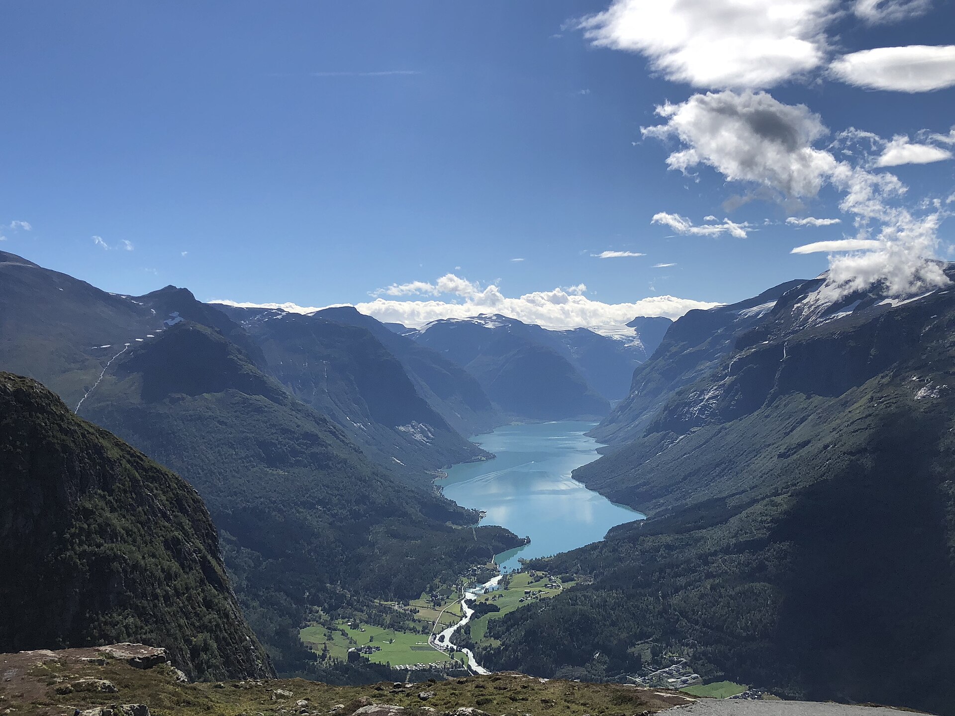
Lovatnet is the turquoise one — glacial flour suspended in meltwater, at its most vivid in strong light and calm conditions in early summer. Nearby, the Loen Skylift climbs to Hoven at 1,011 metres in about five minutes on gradients up to 60 degrees; a summer adult return is around NOK 650, with the season running May to mid-October.
Nærøyfjord
Two hundred and fifty metres wide at its narrowest, walls over a kilometre high, and UNESCO-listed since 2005 — the Sognefjord as a whole is not listed, only this arm and the Geirangerfjord, which several competing articles get wrong. Since 1 January 2026 the smaller boats here run emission-free, so you hear waterfalls instead of an engine. The fjords guide compares them properly.
The rest of the list, by region
Beyond the marquee viewpoints, these are the places worth building a detour around — grouped so you can see what clusters with what.
Fjord Norway
Geirangerfjord. UNESCO-listed since 2005, and the Seven Sisters waterfall drops a total of 410 metres, with the tallest single free fall around 250 metres. Best seen from the Hellesylt car ferry rather than a sightseeing cruise.
Hjørundfjord. The one locals name when you ask which fjord they’d pick. Sunnmøre Alps rising sheer from black water, almost no cruise traffic, and the village of Sæbø as a base. It’s the answer if you’ve already done Geiranger and found it busy.
Lysefjord. Home to both Preikestolen and Kjeragbolten. The fjord itself is 42 km of near-vertical rock, and the Rødne boat from Stavanger runs it for around NOK 890 — see the Stavanger guide.
Hardangerfjord. Fruit blossom in May turns the whole shoreline white and pink, which is a genuinely different kind of Norwegian beauty — gentle rather than sheer. Vøringsfossen, Steinsdalsfossen and the Trolltunga trailhead are all here.
Briksdalsbreen and the Jostedalsbreen arms. Glacier tongues coming down from mainland Europe’s largest icecap. Be aware that they have retreated substantially — several hundred metres in a generation — so photographs from a decade ago flatter what you’ll see. Go anyway, and take the retreat as part of what you’re looking at.
Undredal. Sixty residents, several hundred goats, and Scandinavia’s smallest stave church still in use, seating about 40. Twenty minutes from Flåm, and almost nobody detours.
The interior and the mountains
Jotunheimen. “Home of the Giants” — Norway’s 29 highest peaks, including Galdhøpiggen at 2,469 m. Besseggen, the ridge between Gjende’s green water and Bessvatnet’s blue, is the famous day. Season is roughly June to September.
Rondane and Dovrefjell. Norway’s first national parks, rounder and softer than Jotunheimen, and the only realistic place in Europe to see wild musk ox — reintroduced from Greenland in the 1930s and now a few hundred strong on the Dovre plateau.
Gaustatoppen, Telemark. On a clear day you can see roughly a sixth of mainland Norway from the summit. There’s also a railway inside the mountain, built for NATO, that takes you most of the way up.
Røros. UNESCO-listed copper town of black-tarred timber and turf roofs, essentially unchanged since the 1700s. Under snow, with woodsmoke, it’s the most atmospheric town in Norway.
The far north and the coast
Trollfjord. Two kilometres long, 100 metres wide at its mouth, with walls rising a thousand metres. Only reachable by boat, and the big ships perform a turn inside it that shouldn’t be geometrically possible.
The Helgeland coast. The Kystriksveien road with its six ferries, the Seven Sisters mountain range, the Svartisen glacier reaching almost to the sea, and the Vega archipelago — UNESCO-listed for a thousand-year-old tradition of farming eider ducks for down. The best road trip in Norway that almost no foreign visitor does.
Stetind. Norway’s national mountain: a 1,392-metre granite obelisk rising straight out of the fjord, shaped like an anvil. Voted the national mountain in 2002, and it looks like something drawn rather than eroded.
Mjelle beach, near Bodø. Red-purple sand from garnet in the rock, white shell sand next to it, and turquoise water. Half an hour from a regional airport and usually empty.
Runde. A bird island off Ålesund with around half a million seabirds in season, including puffins from April to August. The colony sits on cliffs you walk along the top of.
Ålesund. Rebuilt entirely in Art Nouveau after the 1904 fire, scattered across islands, and best seen from the Fjellstua viewpoint at the top of 418 steps — particularly at dusk, when the whole town lights up beneath you.
What “beautiful” costs, honestly
One of the better things about a scenery-led trip to Norway is how little of it is ticketed. Almost every entry above is free to look at. What you pay for is reaching it.
| Cost | Typical 2026 price |
|---|---|
| Viewpoints on National Tourist Routes | Free |
| Dalsnibba toll road | NOK 330 per car |
| Trailhead parking (Preikestolen) | NOK 275 over 2 hrs |
| Trailhead parking (Trolltunga P2) | NOK 500/day + NOK 220 toll |
| Loen Skylift return | Around NOK 650 |
| Fløibanen return, summer | NOK 200 online |
| Nærøyfjord boat | NOK 600–800 |
| Hire car per day, summer | NOK 700–1,500 |
| Fuel per litre (Apr–Sep 2026) | NOK 20–21, temporarily reduced |
A week driving the western fjords, camping or self-catering and paying only the tolls and parking above, comes in at a fraction of what a comparable “bucket list” week costs elsewhere in Europe — because the scenery itself has no gate. The costs guide has the full budget picture, and it’s worth knowing that Norway’s new 3% visitor levy, though law since 1 July 2026, is not being charged by any municipality during 2026.
Beauty that isn’t scenery
Worth saying, because a list like this skews hard toward mountains and water: several of the most striking things to look at in Norway are man-made, and they’re what fills a day when the cloud comes down.
The stave churches. Twenty-eight medieval ones survive out of what was once well over a thousand. Urnes, UNESCO-listed and built around 1130, is the oldest; Borgund is the best preserved and easiest to reach, open 15 April to 14 October in 2026 at NOK 150 for adults; Heddal is the largest, 29 metres tall with three turrets. Dark tarred pine, dragon heads on the roof ridges, and 900 years of continuous use.
The Oslo Opera House. Snøhetta’s 38,500 m² slab of Carrara marble rising straight out of the water, designed to be walked on. Free, at any hour.
Bryggen, Bergen. Sixty-two surviving Hanseatic buildings, UNESCO-listed since 1979, rebuilt after the 1702 fire on the original medieval plot lines. Photogenic from the front, far more interesting down the alleys.
The architecture of the tourist routes themselves. This is the underrated one. Norway commissioned serious architects to build the viewpoints — Vøringsfossen’s stepped bridge with its 99 steps, Stegastein’s curving timber ramp, Gudbrandsjuvet’s walkways over the gorge, the rest stops on Aurlandsfjellet. Several are worth stopping for as buildings, independently of what they look at.
Steilneset Memorial, Vardø. Peter Zumthor and Louise Bourgeois, at the far eastern edge of the country, commemorating 91 people burned for witchcraft. A 125-metre fabric-and-timber corridor with 91 lit windows. Free, unstaffed, and almost never visited.
Three mistakes people make on a scenery trip
Driving too far each day. Norwegian roads are slow — reckon on 60 km/h on anything scenic, less with ferries. A day with 300 km of driving in it is a day you spent in a car. Two viewpoints done properly beat six seen through a windscreen.
Booking the wrong month for the wrong region. The fjords need June to September for the passes; the Arctic light peaks in the opposite season. Trying to have both in one trip is the single most common planning error, and the seasons guide exists mainly to prevent it.
Not staying overnight anywhere famous. Geiranger, Flåm, Reine and Preikestolen are all transformed by being there outside the day-visitor window. The same view at 8pm, with the coaches gone and the light low, is a different place from the same view at noon. If you only change one thing about your itinerary, make it this. The accommodation guide covers the small-village options, which fill months ahead in summer.
Northern Norway: where the light does the work
Reine and Reinebringen
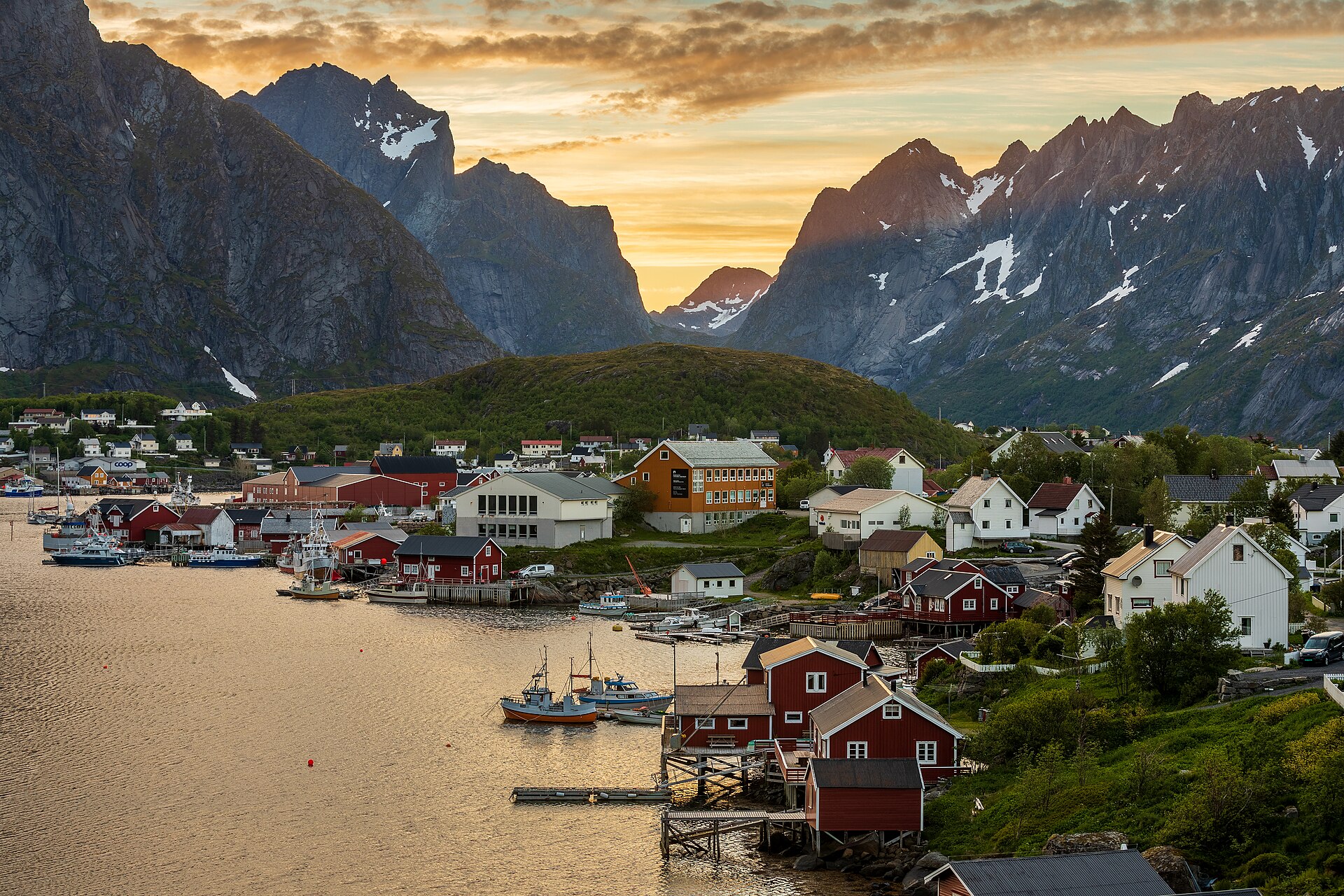
The most photographed panorama in northern Norway, and the rare case where the reality exceeds the picture. Nepalese sherpas laid 1,978 stone steps up Reinebringen, finished in 2021, converting a genuinely dangerous mud scramble into a steep two-to-three-hour climb. Around 41,000 people did it in the year to June 2024, up by half on the year before.
Season is roughly mid-May to the end of September; the stairs are not a winter route. The Lofoten guide covers access and the rest of the islands.
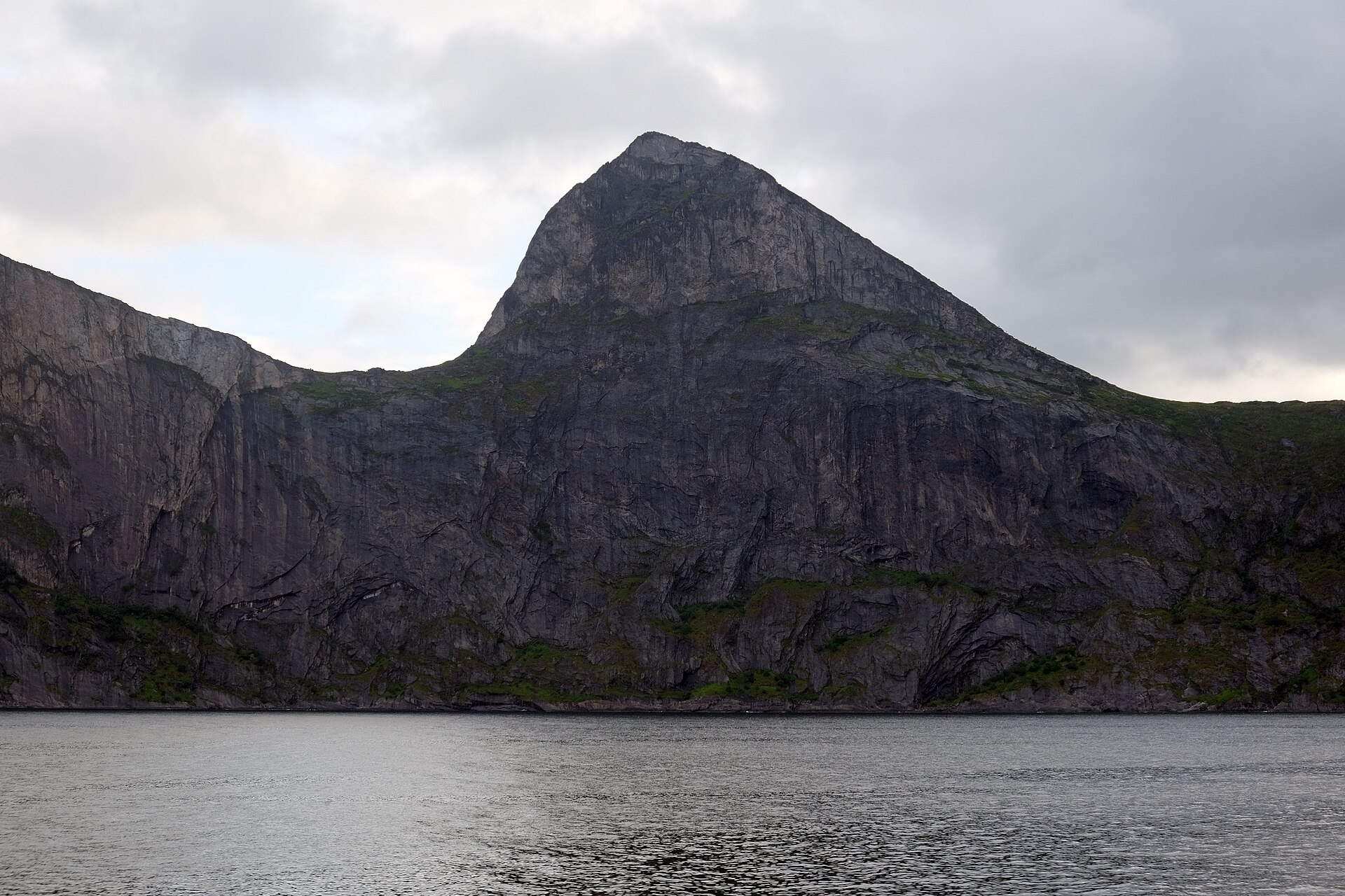
Senja and Segla
Norway’s second-largest island, and what Lofoten was two decades ago. Segla’s overhanging prow is the shot; the Hesten hike to the viewing angle is about 5 km return and takes three hours. The scenic route from Botnhamn to Gryllefjord strings together Tungeneset and Bergsbotn, both architect-designed viewpoints on the National Tourist Route system.
The Lyngen Alps
Peaks rising straight out of the fjord an hour and a half from Tromsø, and almost nobody goes. Best from February to May for ski touring, or in the summer midnight sun for the reflections. See the Tromsø guide for bases.
Svalbard
The strangest light in Norway. Midnight sun runs from 20 April to 22 August — 125 days. Polar night runs 14 November to 29 January, though the mountains delay the sun’s actual reappearance until 8 March. The winter blue hour on snow at 78°N is the single most photogenic condition in the country, and it’s the reason serious photographers go in February rather than July.
When the light actually works
This is the section that separates a scenery trip that works from one that doesn’t, and no competitor attempts it.
Above the Arctic Circle, golden hour lasts for hours. Because the sun tracks low and sideways rather than rising and setting steeply, the warm light that lasts forty minutes in London can last from about 9pm until 1am in Lofoten in June. This is why Arctic landscape photography looks the way it does, and why you should sleep in the afternoon and shoot at midnight.
Midnight sun windows, 2026: North Cape 14 May–29 July, Tromsø 20 May–22 July, Lofoten 28 May–14 July, Bodø 2 June–10 July, Svalbard 20 April–22 August.
In the fjords, the problem is the opposite. Walls a kilometre high mean deep, narrow fjords spend much of the day in shadow. Geiranger and Nærøyfjord are best in the middle of the day when the sun clears the ridge; a 6pm fjord cruise in a narrow arm is often a cruise through shade.
Winter’s compensation is the blue hour. From November to February in the Arctic, the two hours either side of the sun’s non-appearance turn snow lavender and the sky cobalt. It photographs far better than midday, and it’s free.
Drone rules, because people get caught out
Norway’s scenery invites drones and its regulations are stricter than most visitors expect.
A drone under 250 g with a camera requires operator registration. Anything 250 g or over requires an A1/A3 certificate and liability insurance. And separately from the aviation rules, foreign visitors are required to register camera and sensor use with the Norwegian National Security Authority before flying.
Drones are also banned outright in Svalbard’s protected areas, and near airports, which in practice includes a lot of fjord towns. If your plan depends on aerial shots, sort the paperwork before you travel rather than at the trailhead.
The most beautiful places you can reach without a car
A scenery trip is usually assumed to need a car. Several of the best don’t.
- Nærøyfjord — boat from Flåm, train from Bergen or Oslo.
- Preikestolen — ferry and shuttle from Stavanger, around NOK 498 return.
- Flåm Railway and Kjosfossen — 20 km, 20 tunnels, climbing to 867 m, ten departures a day from 1 May to 30 September.
- Bergen Line across Hardangervidda — 492 km at up to 1,222 m, six or seven trains a day, advance fares from around NOK 299.
- Fløibanen and the Vidden plateau, Bergen.
- Fjellheisen, Tromsø, and the whole Arctic tour economy, which collects you from your hotel.
- The coastal voyage, Bergen to Kirkenes — 34 ports, and the scenery comes to you.
The transport guide has the detail, and the cruises guide covers the coastal route.
Two honest caveats about beauty in Norway
Crowds are concentrated, not general. Norway is empty — 5.5 million people in a country the size of Germany — but its famous viewpoints are not. Preikestolen took 348,000 hikers in a single summer. The answer is timing rather than avoidance: start before 8am or after 3pm, and the same place is transformed.
Weather beats planning. Bergen sees rain on roughly 200 days a year. A fjord in cloud is a grey wall. Build a buffer day into any trip where a specific view matters, and treat clear weather as a bonus rather than the plan. If you’re picking your month, the seasons guide has the month-by-month picture, and the itinerary guide has the routes.
A one-week route built purely around scenery
| Day | Where | The view |
|---|---|---|
| 1 | Bergen | Bryggen, Fløyen at sunset |
| 2 | Bergen → Flåm | Nærøyfjord by electric boat |
| 3 | Flåm → Aurland | Stegastein, then the Snow Road if open |
| 4 | Aurland → Geiranger | Gamle Strynefjellsvegen, Lovatnet |
| 5 | Geiranger | Dalsnibba early, Ørnesvingen late |
| 6 | Geiranger → Åndalsnes | Trollstigen, Gudbrandsjuvet |
| 7 | Åndalsnes → Ålesund | Atlantic Road detour, Fjellstua at dusk |
That route only works from roughly mid-June to September, because of the passes. Outside that window, fly north instead and shoot the blue hour.
Frequently asked questions
What is the most beautiful part of Norway?
Lofoten in summer, for the combination of peaks, beaches and light that doesn’t stop. For a first trip in a short window, the Aurlandsfjord and Nærøyfjord from Stegastein and a boat is the highest concentration of spectacle per hour.
What is the most beautiful fjord in Norway?
Nærøyfjord wins on drama and intimacy — 250 metres wide, kilometre-high walls, UNESCO-listed. Geirangerfjord is the classic postcard and the busier one. Hjørundfjord is the quiet alternative if you’ve seen both.
Is Trollstigen open in 2026?
Yes. It reopened on 27 April 2026, its earliest opening on record, after two seasons closed for rockfall works. It runs through October or November, weather permitting, with occasional short closures in heavy rain. Some pages online still show the old closure notice.
When is the best time to visit Norway for scenery?
Late June to early July if you want the midnight sun and every mountain road open. September for autumn colour, still water and far fewer people. February for Arctic blue hour and aurora.
Which is more beautiful, the fjords or the north?
The fjords are more dramatic per square kilometre and far easier to reach. The north is stranger, emptier and better for light. For a first visit, the fjords; for a second, the north.
Do I need a car to see the best scenery?
No, but it helps for the National Tourist Routes and the mountain passes, which is where a lot of the best scenery is. The Nærøyfjord, Preikestolen, the Flåm and Bergen railways and Tromsø are all reachable without one.
Can I fly a drone in Norway?
With the right paperwork. Under 250 g needs operator registration; 250 g and over needs an A1/A3 certificate and insurance. Foreign visitors must also register camera and sensor use with the National Security Authority, and drones are banned in Svalbard’s protected areas and near airports.
How many days do you need to see Norway’s best scenery?
Seven for the western fjords, done properly rather than driven past. Ten to fourteen to add the north. Under five days, pick one fjord arm and go deep.
Photo credits
All photographs are used under their respective Creative Commons or public-domain licences.
- Reine, Lofoten. Best photographed between 10pm and 1am in June, when the sun tracks sideways. — Photo: Ximonic (Simo Räsänen) / CC BY-SA 4.0 via Wikimedia Commons.
- Segla on Senja — Photo: kallerna / CC BY-SA 4.0 via Wikimedia Commons.
- Lovatnet from Hoven. The colour is glacial flour suspended in meltwater — Photo: Armatus1995 / CC BY-SA 4.0 via Wikimedia Commons.
Road openings, tolls and parking rules were checked in July 2026 and are given in Norwegian kroner at roughly 9.5 NOK to 1 USD. Mountain passes open and close with the snow — always check current status before building a day around one.