Every norway road trip itinerary I read before my first drive told me the same three things: Bergen is lovely, Trollstigen has hairpins, and the fjords are big. Not one of them told me what the Geiranger–Hellesylt ferry actually costs, how often it sails, or that the discount card I had just bought did nothing on it. I found that out at the ticket booth.
So this is the day-by-day plan I wish I’d had. A 7-day core loop out of Oslo and a 10-day extended version, each leg with its real distance and driving time, every named ferry crossing with a fare and a frequency, and a table of exactly which named stretches of road shut in winter and what you drive instead.
I’ve left out the mechanics. Tolls, AutoPASS chips, fuel, winter tyre law and one-way hire fees are all covered in the companion piece on how driving actually works in Norway. This article assumes you have wheels and want to know where to point them.
One decision up front, because it shapes everything: I run the loop anticlockwise from Oslo, out through Valdres on the E16 and back down the E6 through Gudbrandsdalen. That puts the fjords in the middle of the trip and leaves the two long transit days bookending the good stuff instead of interrupting it.
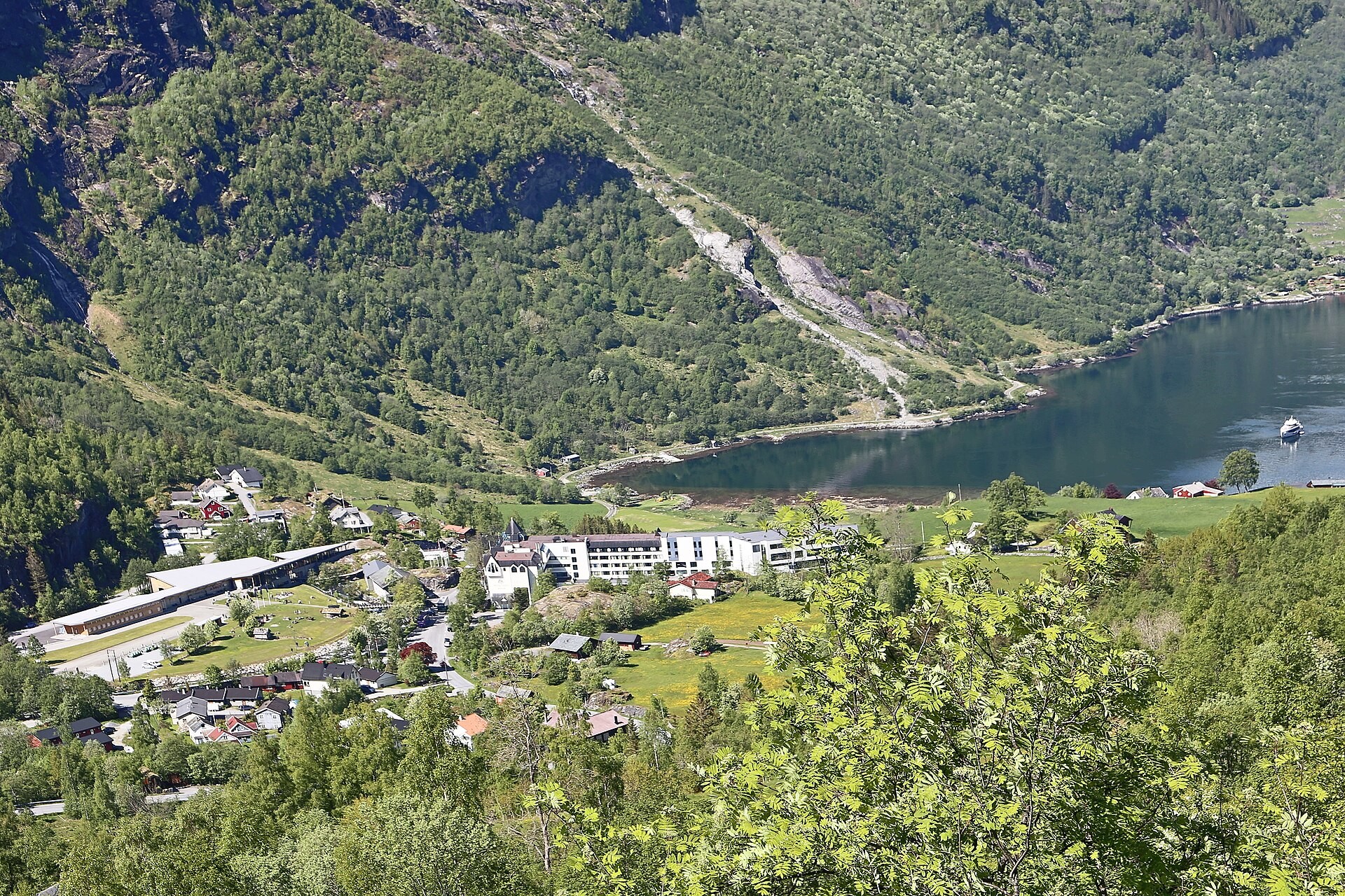
The two routes at a glance
Distances are road distances rounded to the nearest 5 km. Driving times are moving time, with ferry crossings added where they apply. They exclude stops, and you will stop constantly, so add a third on top of every figure.
| Day | 7-day core loop | Distance | Driving | 10-day extended version |
|---|---|---|---|---|
| 1 | Oslo to Aurland (E16, Valdres) | 330 km | 5 h | Same |
| 2 | Aurland to Bergen via Flåm and Voss | 195 km | 3 h 30 | Same |
| 3 | Bergen, on foot | 0 km | 0 | Same |
| 4 | Bergen to Loen (E39, two ferries) | 370 km | 6 h 30 | Bergen to Sogndal (one ferry), 215 km, 4 h |
| 5 | Loen to Geiranger via Dalsnibba | 90 km | 2 h | Sogndal to Loen (one ferry), 175 km, 3 h 15 |
| 6 | Geiranger to Otta via Trollstigen | 220 km | 4 h | Loen to Geiranger via Dalsnibba, 90 km, 2 h |
| 7 | Otta to Oslo (E6) | 330 km | 4 h 30 | Geiranger to Ålesund by ferry, 110 km, 2 h + 65 min afloat |
| 8 | — | — | — | Ålesund to Åndalsnes plus Trollstigen, 215 km, 4 h |
| 9 | — | — | — | Åndalsnes to Oppdal via the Atlantic Road, 320 km, 5 h |
| 10 | — | — | — | Oppdal to Oslo (E6), 390 km, 5 h 15 |
| Total | Oslo loop | 1,535 km | ~25 h | 2,110 km, ~33 h |
The seven-day version has one genuinely hard day (day 4) and one long one (day 7). The ten-day version has none over five and a quarter hours, because the extra days break up the E39 coast run and buy you the Geiranger–Hellesylt ferry instead of a mountain detour. The ten-day plan is not the seven-day plan with three sights bolted on; it is the same route driven at a speed that lets you look out of the window.
Before day 1: Valdres or Hardangervidda?
Oslo to Bergen has two real options and every itinerary I checked picks one silently without telling you there was a choice. Here is the comparison nobody prints.
The E16 through Valdres is about 490 km and takes 5 h 30 to 6 h 30. It is the longer line on the map and the faster one in practice, because it stays low, tunnels through the worst of the terrain, and is the route Norway intends to keep open in all weather. It is also the road that delivers you to Lærdal, Aurland and Flåm, which is why my itinerary uses it.
The Rv7 over Hardangervidda is about 470 km but takes seven hours or more. Twenty kilometres shorter, ninety minutes slower. It crosses Europe’s largest high mountain plateau, bleak and treeless, and it is nominally open all year. In practice it gets kolonnekjøring, convoy driving behind a plough, and short closures in storms from roughly November to April.
My call: take the E16 out and, if you have a spare day, come back over Hardangervidda or drop south into the Hardanger orchards rather than doing it as a transit slog. Hardangervidda is a destination masquerading as a shortcut. Treating it as a way to get to Bergen faster is the single most common planning mistake in a norway driving route, and it isn’t even faster.
The 7-day core loop, day by day
Day 1: Oslo to Aurland — 330 km, 5 h driving, no ferries
Out of Oslo on the E16 through Hønefoss and into Valdres. The first two hours are unremarkable; Norway does not start being Norway until you’re past Fagernes. The scenery is a slow build, not a reveal.
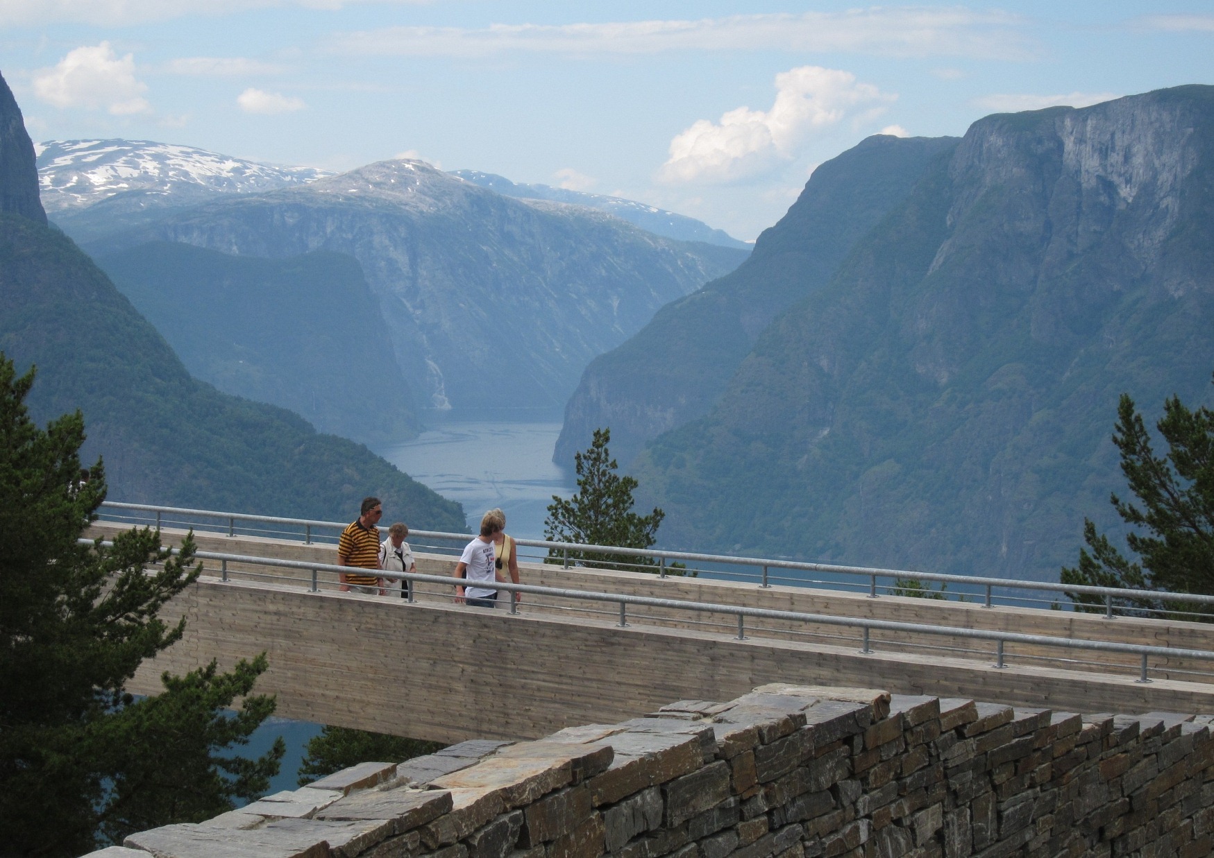
The leg’s one real decision comes at Lærdal. Take the Lærdal Tunnel, 24.5 km, the longest road tunnel in the world, toll-free, about twenty minutes end to end with three blue-lit caverns breaking up the monotony. Or climb the Aurlandsfjellet Snow Road over the top, about an hour, which delivers you to the Stegastein platform above Aurlandsfjord. The Snow Road opens in early June and closes in mid-October; outside that window the decision makes itself.
Take the Snow Road if it’s open and you’re arriving before dusk. It is the better hour of driving by a wide margin. Take the tunnel if you’re tired, if the weather has closed in, or if someone in the car dislikes exposed drops. Sleep in Aurland or Flåm.
Day 2: Aurland to Bergen — 195 km, 3 h 30 driving, no ferries
The short driving day of the first half, and that is the point. Start in Flåm, twenty minutes down the fjord from Aurland, and decide what you’re doing with the morning.
Option one is the Flåm Railway up to Myrdal and back, roughly an hour each way. Option two is a fjord cruise along Aurlandsfjord into the Nærøyfjord, the narrow UNESCO-listed arm that is the most photographed stretch of water in the country. Option three is neither: drive up to Stegastein if you skipped it yesterday and be in Bergen by lunch.
On the railway fare I have to be straight with you, because the published numbers do not agree. The operator’s own range for 2026 runs from 430 NOK ($46) one way in low season to 510 NOK ($55) in high season, with returns between 620 and 730 NOK ($66–$78), checked April 2026. A second source quotes a flat 510 NOK ($55) one way. Eurail lists 245 NOK ($26) from October to December and 315 NOK ($34) from May to September, but those are 30 percent rail-pass-holder fares, not walk-up prices, and note that 315 divided by 0.7 comes to 450, not 510, so the two sets don’t reconcile cleanly. One outlier site claims about 570 NOK ($61) one way and 850 NOK ($91) return. Assume 500 NOK ($53) a head one way at a summer ticket window and be pleased if it’s less.
Then E16 west through Voss to Bergen. Good road, frequent tunnels, and a slow last forty minutes in traffic. Park once and leave the car parked.
Day 3: Bergen — 0 km
No driving. This is not a rest day I’ve padded the itinerary with; it’s structural. Day 4 is the hardest driving of the trip and doing it on tired legs is how people end up hating their own holiday.
Bergen absorbs a day easily: Bryggen, the Fløyen funicular, the fish market (touristy and priced accordingly, eat one block back instead), the Ulriken walk if the weather holds. It rains here about 240 days a year. Plan for it rather than being surprised by it; the seasonal weather patterns are well documented and Bergen’s reputation is earned.
If sitting still makes you twitchy, there is a Hardanger day loop — Bergen to Norheimsund and back, about 200 km. It’s pleasant. It is also four hours of driving the day before six and a half more.
Day 4: Bergen to Loen — 370 km, 6 h 30 including two ferries
The hard one. North out of Bergen on the E39, the coastal spine of western Norway, which involves crossing water because there is no way around it.
First is Oppedal–Lavik across Sognefjord, about 6 km and 20 minutes on an electric ferry. Second is Anda–Lote across Nordfjord, a shorter hop. Both are public AutoPASS crossings, both run frequently enough that turning up and joining the queue is normal practice, and both add roughly half an hour each to the day once you count waiting and loading.
You cross the mouth of Sognefjord here rather than driving up it. It is a working ferry route, not a sightseeing cruise. Leave Bergen by 08:30, because six and a half hours of moving time becomes eight and a half with two ferries, a lunch and the four times you will pull over. Overnight at Loen or Stryn.
Day 5: Loen to Geiranger — 90 km, 2 h driving, 330 NOK toll
Ninety kilometres, two hours, the day the trip earns itself back. Rv15 east from Stryn, then the Rv63 turn south at Grotli towards Djupvasshytta. From there the Dalsnibba toll road climbs to the Geiranger Skywalk, and the cost in 2026 is 330 NOK ($35) per car, not per person, checked September 2026. It opens mid-to-late May and closes in October. From the top you look straight down the length of the fjord. Of every paid viewpoint in Norway this is the one I’d pay for again, and I resent paying for views — there’s a fuller ranking of where the fjord views are worth the detour if you’re choosing.
Then the descent into Geirangerfjord, which is a series of switchbacks with the Seven Sisters waterfall on the far wall. Arrive early enough to be in the village before the cruise ships disgorge, or late enough that they’ve gone. Between 10:00 and 16:00 in July, Geiranger holds several thousand more people than it has room for.
Day 6: Geiranger to Otta via Trollstigen — 220 km, 4 h driving
Out of Geiranger up the Ørnevegen, the Eagle Road, eleven bends with the classic down-the-fjord viewpoint at the top. Then the Linge–Eidsdal ferry and on to Valldal.
From Valldal, Trollstigen. Eleven hairpins, a summit at Stigrøra of 858 m, a bridge over the Stigfossen waterfall, and a gradient that makes a loaded campervan work. It reopened on 27 April 2026, its earliest opening on record, and runs to October or November. Short closures for residual work remain possible, so check before you commit: this road was shut for roughly a year from June 2024 after a rockslide hit a car, and only reopened on 11 July 2025.
Down into Åndalsnes, then E136 and E6 south through Dombås to Otta. The last two hours are ordinary valley driving and you’ll be glad of the break from concentration.
Day 7: Otta to Oslo — 330 km, 4 h 30 driving
E6 down Gudbrandsdalen through Lillehammer and Hamar. Mostly motorway, mostly dull, heavily tolled. Set off at nine and you’re in Oslo by three with a lunch stop. If you have a midday flight, drive on to Lillehammer on day 6 instead.
The 10-day extended version
Days 1 to 3 are identical. From day 4 the route splits, and the difference is not more stops, it is more room.
Day 4: Bergen to Sogndal — 215 km, 4 h including one ferry
Same E39 start, same Oppedal–Lavik crossing, but you turn inland and stop at Balestrand or Sogndal instead of pushing on. Half the driving of the seven-day day 4. Balestrand is a Victorian resort village with almost nothing to do in it, which after three days of moving is the point.
Day 5: Sogndal to Loen — 175 km, 3 h 15 including one ferry
North on Rv5 through the Fjærland tunnels with the Jostedalsbreen glacier arm off to the right, then across on the Anda–Lote ferry to Nordfjord.
Day 6: Loen to Geiranger — 90 km, 2 h, 330 NOK toll
As day 5 of the core loop. Dalsnibba, the descent, an early arrival, and a whole afternoon in Geiranger rather than a rushed evening.
Day 7: Geiranger to Ålesund — 65 min ferry plus 110 km, 2 h
This is the day the ten-day plan exists for. Instead of driving out over the Ørnevegen you board the Geiranger–Hellesylt ferry and sail the full length of Geirangerfjord, past the Seven Sisters and the Suitor, in 65 minutes. It runs April to October. It is also the single most expensive piece of tarmac-adjacent transport on this route and the one every other itinerary gets wrong. Full numbers in the table below.
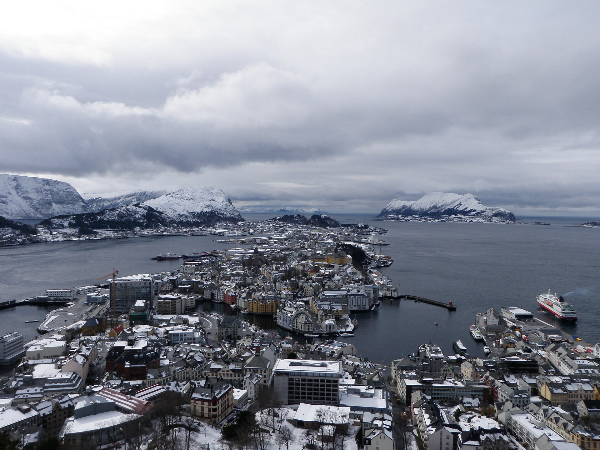
From Hellesylt, Rv60 north through Stranda to Ålesund, a couple of hours. The town is art nouveau throughout because it burned down in 1904 and was rebuilt in one go. Climb the Aksla steps at sunset.
Day 8: Ålesund to Åndalsnes with Trollstigen — 215 km, 4 h
E39 and E136 east to Åndalsnes, about 125 km and two hours, with the Romsdalen valley walls closing in as you go. Drop the bags, then drive Trollstigen as an out-and-back from the north: up the eleven hairpins to Stigrøra, look at the Stigfossen bridge, come down again. Ninety kilometres round trip, roughly two hours with stops.
Out-and-back beats transit here. You drive it in both directions, you can time it for a gap in the coach traffic, and you are not committed to being somewhere else by evening.
Day 9: Åndalsnes to Oppdal via the Atlantic Road — 320 km, 5 h
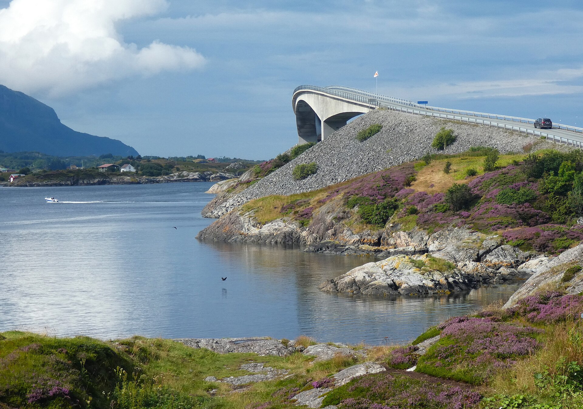
North with the Molde–Vestnes ferry to start the leg, then the run out to the Atlantic Road: 8,274 m of causeway across eight bridges between skerries, of which the Storseisundet Bridge is the one on every postcard at 260 m long with 23 m of clearance. Åndalsnes to Kristiansund is about 2 h 30 of driving with one ferry, Åfarnes–Sølsnes.
Then Rv70 inland to Oppdal, which sets up a manageable final day. Honest assessment of the Atlantic Road: it takes ten minutes. In flat calm it’s a nice bridge. In a westerly gale with spray coming over the rail it is one of the great drives in Europe. You do not choose which one you get.
Day 10: Oppdal to Oslo — 390 km, 5 h 15
E6 south the whole way through Dombås and Lillehammer. Long, straightforward, tolled.
The ferry table nobody else prints
First, honesty about what I can stand behind. Norwegian public ferry tariffs move with the annual regulated price list and most operators don’t publish a clean per-vehicle table you can cite. Rather than invent plausible-looking fares I’ve given crossing times where I have them, the exact fare where I have it, and a blunt “verify” where I don’t. The one fare I can give you to the krone is the one that costs real money.
| Crossing | Road | Time afloat | Fare, car + passengers | AutoPASS | Season / notes |
|---|---|---|---|---|---|
| Geiranger–Hellesylt | Rv60 | 65 min | 1,534 NOK ($164) one way, car under 6 m + 3 adults, incl. 174 NOK berth fee (June 2026). Fjordtours fixed Car Package, car + driver + up to 4 passengers: 1,650 NOK ($176) summer, about 1,680 NOK ($180) winter | No. Privately operated, outside the public system | April to October. Frequency disputed: see note below |
| Oppedal–Lavik | E39 | 20 min (about 6 km) | Public regulated tariff — verify at the booth or in the operator app, September 2026 | Yes, 50% with prepaid agreement | Year-round. Electric vessel |
| Anda–Lote | E39 | Short hop, under 15 min | Public regulated tariff — verify | Yes, 50% | Year-round |
| Festøya–Solevåg | E39 | About 15 min | Public regulated tariff — verify | Yes, 50% | Year-round |
| Linge–Eidsdal | Rv63 | Short hop | Public regulated tariff — verify | Yes, 50% | Year-round. The Geiranger side road is seasonal |
| Molde–Vestnes | E39 | Short hop | Public regulated tariff — verify | Yes, 50% | Year-round. Starts the leg south from Molde |
| Åfarnes–Sølsnes | Fv64 | Short hop | Public regulated tariff — verify | Yes, 50% | Year-round. The one ferry on Åndalsnes–Kristiansund |
| Horten–Moss | Oslofjord | Cross-fjord | Operator tariff — verify | Partial, 30% only | Year-round. Private operator, reduced discount |
The correction that matters. An AutoPASS for Ferry prepaid agreement gives 50 percent off public crossings, and only 30 percent on a few private ones such as Horten–Moss. Geiranger–Hellesylt gives you nothing: it is privately operated and sits outside the public AutoPASS system entirely. Every itinerary I read implies the card halves all your ferry costs. On the crossing that costs 1,534 NOK it halves nothing. Budget the full amount — it is a meaningful line in any realistic Norway trip budget.
The frequency conflict. Sources disagree badly on how often Geiranger–Hellesylt sails. One set of timetables shows up to 18 departures a day each way at peak, 08:00 to 18:30. Another, for August 2026, shows 7 per weekday between 08:30 and 17:30. That is not a rounding difference; it is operator- and month-dependent. Check your actual date on the operator’s timetable, and if a hotel booking depends on a specific sailing, book the ferry.
Which named legs close in winter, and what you drive instead
This is the other table nobody prints. Half of the road surface in the itinerary above does not exist between November and May. If you’re planning a cold-season drive, read this alongside the wider guide to what Norway is like out of season and then rebuild your route around what’s left.
| Named leg | Closed roughly | Why | What you drive instead |
|---|---|---|---|
| Trollstigen (Rv63, Valldal–Åndalsnes) | Late Oct/Nov to late April. Reopened 27 April 2026 | Snow, plus rockfall risk on the wall above the hairpins | E136 Åndalsnes–Ålesund. There is no winter route over the pass, only around it |
| Rv63 Geiranger–Djupvasshytta–Grotli | Roughly Nov to May | High exposed pass | Rv60 via Hellesylt and Stranda, or approach Geiranger from Linge–Eidsdal |
| Dalsnibba toll road | Nov to mid/late May | Summit road at 1,500 m | Nothing. The viewpoint is simply shut |
| Sognefjellet (Rv55, Lom–Sogndal) | Roughly Nov to mid-May | Northern Europe’s highest pass at 1,434 m | E16 and the Lærdal Tunnel, or Rv15 over Strynefjellet |
| Aurlandsfjellet Snow Road (Aurland–Lærdal) | Mid-Oct to early June | Name is a clue | Lærdal Tunnel, 24.5 km, toll-free, 20 min instead of 60 |
| Geiranger–Hellesylt ferry | Nov to March | Seasonal tourist route, April to October | Rv60 road around via Stranda, or drop Geiranger from a winter plan |
| Rv7 Hardangervidda | Nominally open all year | Storms bring convoy driving and short closures | E16 through Valdres, the route meant to stay open in all weather |
| Atlantic Road | Open all year | Closes in storms when waves break over the deck | Rv70 inland via Batålia. Check before setting off in a gale |
The upshot: a winter norway road trip plan is Oslo–Valdres–Flåm–Bergen out and back, with a Hardanger loop if conditions allow. Geiranger, Trollstigen, Dalsnibba and Sognefjellet are a summer package and you cannot part-buy it. Winter drivers wanting more than that should look at the pass-free south-coast drive.
What I’d cut, and what’s overrated
Cut day 3 in Bergen before anything else if you’re squeezed to six days. It hurts, and it’s still right, because the alternative is cutting Geiranger and the whole trip is shaped around getting there.
The Flåm Railway is optional. A well-run hour on a pretty line, and at roughly 500 NOK ($53) a head one way it is not the best value here. If you’re driving the Snow Road and taking a Nærøyfjord cruise, the railway is a third version of the same landscape. Do two of the three.
The Geiranger–Hellesylt ferry is worth 1,534 NOK. I resented the price and I’d pay it again. Sixty-five minutes at water level down a fjord you spent three days approaching from above is a different thing from looking at it. But take it as transport that happens to be scenic, on a day you were going that way, not as an out-and-back excursion.
The Atlantic Road is overrated in good weather and underrated in bad. It is a ten-minute drive that people build two days around.
The honest driving-hours truth. Competing itineraries admit to four to eight hours a day and treat “you will be in the car often” as a footnote. It isn’t. The seven-day loop is roughly 25 hours of moving time over six driving days: a real four-hour average and one day near seven. The answer is not to drive faster. It is to take ten days, or to fly into Bergen and drive one way to Ålesund without the Oslo transit legs. There are other route shapes in the main Norway itinerary planner.
Common questions
How many days do you need for a Norway road trip?
Seven is the minimum that reaches the fjords from Oslo and gets home, and it costs you one seven-hour driving day. Ten is the number at which the trip stops feeling like a transit exercise; no day exceeds five and a quarter hours. Under seven days, fly into Bergen and skip the Oslo legs entirely. With two weeks, switch to the fourteen-day driving loop.
Should I start in Oslo or Bergen?
Oslo if you want a loop and cheaper flights, Bergen if you have under a week. Starting in Bergen puts you three hours from the good stuff instead of five, but a one-way car hire back to Oslo carries a drop-off fee that can wipe out the saving. Price both before deciding.
Hardangervidda or Valdres between Oslo and Bergen?
Valdres on the E16, about 490 km in 5 h 30 to 6 h 30, is the faster and more weather-reliable line. Rv7 over Hardangervidda is 470 km but takes over seven hours and sees convoy driving in winter. Take Hardangervidda as a destination, not a shortcut.
Do you need to book Norwegian car ferries in advance?
Not for the public E39 crossings; you queue, you board, you pay on the deck. Geiranger–Hellesylt is different: seasonal, disputed frequency, and full of coaches in July. Book that one if your day depends on it.
Is Trollstigen open in 2026?
Yes. It reopened on 27 April 2026, its earliest opening on record, and should run to October or November. Short closures for residual work are still possible, and the road was shut for about a year from June 2024 after a rockslide hit a car. Check road status the morning you plan to drive it.
How much is the Geiranger–Hellesylt ferry?
1,534 NOK ($164) one way for a car under 6 m plus three adults, including a 174 NOK berth fee, as of June 2026. Fjordtours sells a fixed Car Package covering car, driver and up to four passengers at 1,650 NOK ($176) in summer. Your AutoPASS discount does not apply.
Can you road trip Norway in winter?
You can drive Oslo–Valdres–Flåm–Bergen and the Hardanger fjord roads year-round on winter tyres. You cannot drive Trollstigen, Sognefjellet, Dalsnibba or the Grotli approach to Geiranger, and the Geiranger ferry doesn’t run. Rebuild the route rather than hoping. If your dates sit near either end of the summer season, check the weeks to avoid first.
Is the Flåm Railway worth it if you already have a car?
Marginally. Around 500 NOK ($53) one way at a summer window buys an hour of scenery you can partly get from the Snow Road and the Nærøyfjord cruise. Take it if you want a break from driving, skip it if you’re doing both of the others. Published fares vary widely.
What does the whole trip cost to drive?
Fuel, tolls, ferries and parking on the seven-day loop run to a four-figure NOK sum before accommodation, with the Geiranger ferry and the 330 NOK Dalsnibba toll the largest discretionary items. The week-long breakdown and the ten-day version go into per-day spend.
Photo credits
- Geiranger is the pivot of the seven-day loop, and the ferry out of it is the expensive one. — Photo: W. Bulach / CC BY-SA 4.0 via Wikimedia Commons.
- The Atlantic Road is 8,274 metres and eight bridges, and it costs nothing to drive. — Photo: Bingar1234 / CC BY-SA 4.0 via Wikimedia Commons.
- Stegastein sits on the Aurlandsfjellet road, which is shut from mid-October. — Photo: Erik den yngre / CC BY-SA 3.0 via Wikimedia Commons.
- Alesund is the natural overnight between the Atlantic Road and Geiranger. — Photo: Manxruler / CC BY-SA 3.0 via Wikimedia Commons.
Prices and road status checked September 2026, with the Geiranger–Hellesylt fare dated June 2026 and Flåm Railway fares dated April 2026. Norwegian ferry tariffs, toll rates and mountain pass opening dates change every season — verify anything load-bearing before you drive it.