Last updated: June 2026
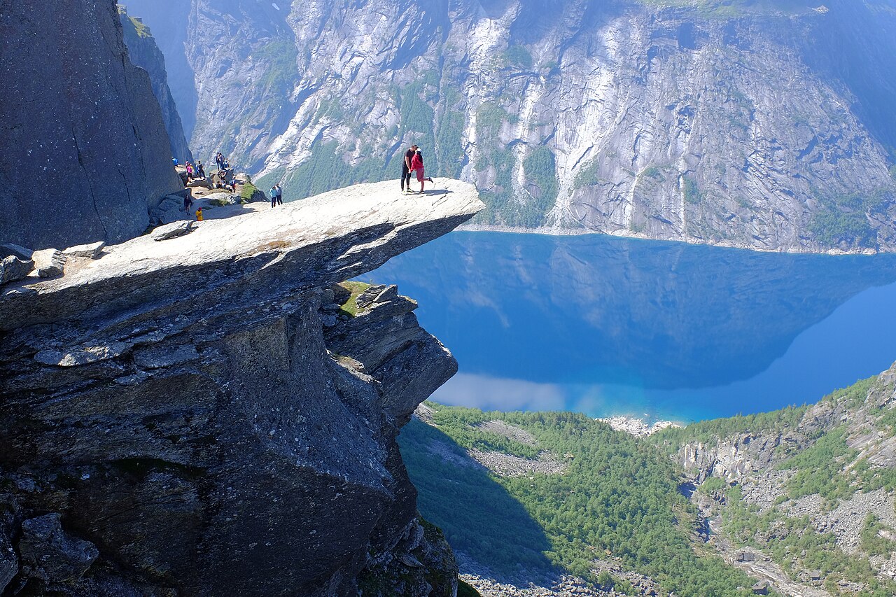
I still remember the moment the trail crested above Ringedalsvatnet and I saw that absurd tongue of rock hanging over 700 metres of nothing. I’d hiked 13 kilometres to get there, my legs were finished, and none of it mattered. That’s the deal Norway offers walkers: it asks a lot and pays you back double.
Hiking in Norway is free, gloriously unregulated, and world-class: no trail permits, no park entry fees, a legal right to roam (and wild camp) almost anywhere, 47 national parks, and more than 20,000 km of marked routes linked by 550+ mountain huts. The season for the famous hikes runs roughly June through September. You pay only for parking, boats and beds.
That’s the short version. The long version — which hikes are actually worth your limited days, how hard they really are, what everything costs in kroner, how to do it all without a car, and the unwritten rules Norwegians assume you know — is below. I’ve structured this as the hub for our entire Norway hiking section, so where a trail deserves its own deep-dive (Trolltunga, Preikestolen, Kjerag and friends), I’ll give you the honest summary here and link out as those guides go live.
Norway’s famous hikes at a glance
Six hikes dominate every Norway daydream, and for once the hype is mostly earned. Here’s the side-by-side nobody on page one of Google seems willing to build — distances are round trip unless noted, and parking fees are 2026-season figures (they creep up most years):
| Hike | Distance | Ascent | Time | Difficulty | Season | Base town | Parking |
|---|---|---|---|---|---|---|---|
| Trolltunga | 27 km (20 km from P3) | ~800–1,200 m | 8–12 hrs | Very demanding | Jun–Sep self-guided | Odda | NOK 550/day (P2) |
| Preikestolen | 8 km | ~500 m | 4–5 hrs | Moderate | Year-round (spikes in winter) | Stavanger | NOK 275/day |
| Kjeragbolten | 11 km | ~750 m | 5–6 hrs | Demanding | ~Late May–Oct | Stavanger / Lysebotn | NOK 300 |
| Besseggen | 14 km one way | ~1,100 m | 6–9 hrs | Demanding | Jul–late Sep | Gjendesheim | Boat NOK 260 one way |
| Romsdalseggen | 10 km one way | ~970 m | 7–8 hrs | Demanding, exposed | Jul–Sep | Åndalsnes | Shuttle bus from town |
| Reinebringen | ~2 km + walk-in | ~450 m | 2–3 hrs | Short but brutal | May–Sep | Reine (Lofoten) | Free-ish in Reine; walk to trailhead |
If you only take one thing from this guide: match the hike to your actual fitness, not your camera roll ambitions. Preikestolen is achievable for most reasonably active people. Trolltunga is a 10-hour mountain day that ends more rescues than any other trail in Norway. They are not the same outing, whatever Instagram implies.
Quick facts: what makes Norway different
- Trails are free. No permits, no entry fees, no reservations for the paths themselves. Anywhere. You pay for parking (NOK 100–600), the odd boat, and beds.
- The right to roam is law. Allemannsretten lets you walk and camp on uncultivated land nationwide — more on the fine print below.
- Marking is superb. Red “T”s painted on cairns and rocks mark the Norwegian Trekking Association (DNT) network — over 20,000 km of it.
- Weather is the boss. Summit conditions run about 10°C colder than the fjord below, and fog or sleet in July is normal, not bad luck.
- Emergency numbers: 113 (medical), 112 (police). Mountain rescue in Norway is free — and largely run by volunteers, so don’t make them come get you for a sprained ego.
- Plan with UT.no (DNT’s trail planner) and check weather on yr.no. Norwegians refresh yr the way other nations check football scores.
Allemannsretten: the right to roam (and camp) explained
Norway’s Outdoor Recreation Act of 1957 codified something older than the country itself: everyone may travel on foot across uncultivated land — utmark — regardless of who owns it. Forest, mountain, moor, beach: if it isn’t a farmyard, a planted field or someone’s garden, you may walk there. You may also pick berries and mushrooms as you go, which in August is less a legal footnote than a meal plan.
The camping rules are equally generous, with three catches worth memorising:
- Pitch at least 150 metres from the nearest inhabited house or cabin.
- Maximum two nights in the same spot in lowland areas without the landowner’s permission. In the high mountains and genuinely remote country, you can stay longer.
- No open fires between 15 April and 15 September in or near forest and vegetated land. Disposable barbecues count as fires. Established fire pits and bare rock by the water after days of rain are the usual common-sense exceptions, but local total bans override everything — check before you strike a match.
Two local wrinkles at the honeypots: you cannot camp or sleep in vehicles at the Trolltunga, Preikestolen or Kjerag car parks, and on the Trolltunga plateau itself camping is allowed only in zones marked with tent symbols on the official map. The cultural rule underneath all of it is sporløs ferdsel — travel without trace. Pack out everything, including toilet paper. Norwegians will not say anything if you don’t. They will simply think it, forever.
How Norway grades its trails — and how hard they really are
Norwegian trails use a ski-slope colour system: green (easy, family-friendly), blue (moderate, some climbing), red (demanding — proper mountain terrain, sustained ascents), and black (expert — exposure, scrambling, route-finding). Any hike over 20 km, whatever the terrain, gets bumped to “very demanding,” which is how Trolltunga earns its rating.
Here’s my honest translation layer, because “demanding” means different things to different knees:
- If a 90-minute walk is a big outing for you: stick to green and blue — Bondhusvatnet, Sognsvann, Fløyen via the funicular. You’ll still get postcard Norway.
- If you can comfortably walk 10 km with 500 m of climbing: Preikestolen, Ryten, Gaustatoppen and Reinebringen (slowly) are yours.
- If you can do 20 km with 800 m of ascent and still smile: that is the official Trolltunga benchmark, and Besseggen, Kjerag and Romsdalseggen sit in the same band.
- Heights are their own axis. Besseggen and Romsdalseggen involve hands-on-rock scrambling with real drops. Kjerag’s chains are airy. If exposure rattles you, Trolltunga is long but never scary — and Preikestolen’s edge is entirely optional.
The big three: Trolltunga, Preikestolen and Kjerag
Three rock formations around the Hardanger and Lysefjord region have become Norway’s holy trinity of hikes. They’re geographically close enough to combine in one trip — our Norway itinerary guide shows how — but they are wildly different days out. (Deciding between them? We’re publishing a full Trolltunga vs Preikestolen vs Kjerag comparison as part of this hiking series.)
Trolltunga: the troll’s tongue
27 km round trip from P2 Skjeggedal | ~800 m net ascent (closer to 1,200 m cumulative) | 8–12 hours | Very demanding | Self-guided season: 1 June–30 September
The most famous photograph in Norwegian tourism is taken from a slab of gneiss jutting horizontally over the Ringedalsvatnet reservoir, 700 metres up. Around 80,000 people a year make the pilgrimage — up from 800 in 2010, a statistic that explains everything about modern hiking.
The standard route from Skjeggedal (P2) is 27 km round trip; the first 4 km climb brutally, then the plateau rolls. Most people take 10 hours. You can cut it to 20 km by pre-booking one of just 30 parking spots at Mågelitopp (P3, NOK 600 plus a NOK 220 road toll, sells out weeks ahead in July) or taking the P2–P3 shuttle. P2 parking costs NOK 550 a day (about $58); the Odda Buss shuttle runs from town from roughly late May to late September, with first departures before 6 am for exactly the early start you want.
Outside the June–September window the trail is officially guided-only territory — winter trips on snowshoes run NOK 1,550–1,950 with outfits like Trolltunga Active. The photo queue at the ledge hits 30–45 minutes on July weekdays and worse on Saturdays; start before 7 am or aim for late afternoon. Hardy souls camp on the plateau (legal, in the marked zones) for a private sunrise on the tongue. Trolltunga was recently designated one of Norway’s official National Tourist Trails, which in practice means better stewardship and signage. Our full Trolltunga guide — route choices, the via ferrata option, camping spots — is coming soon in this series.
Preikestolen: the essential first hike
8 km round trip | ~500 m ascent | 4–5 hours | Moderate | Year-round (microspikes in winter)
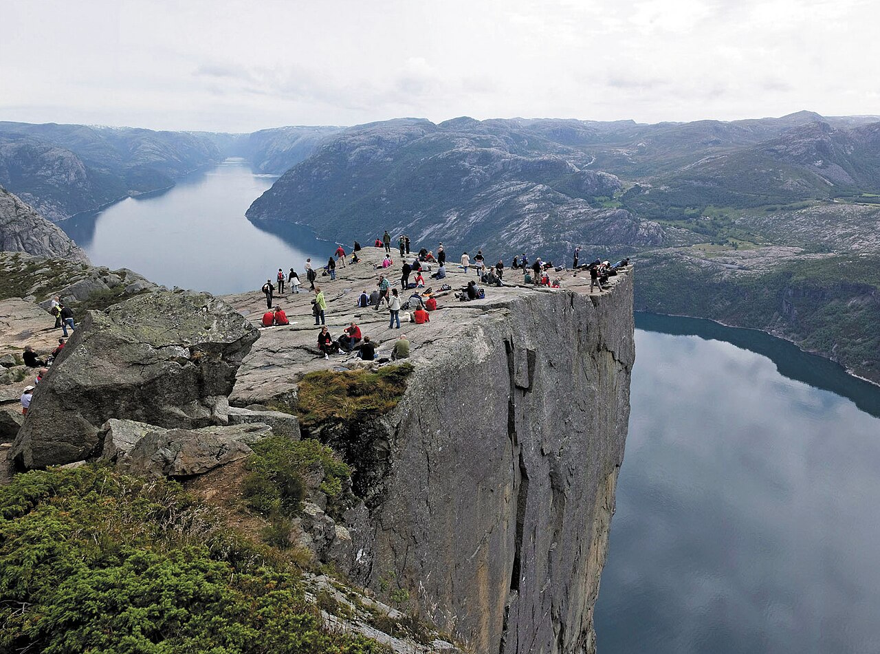
Pulpit Rock is the one I recommend to almost everybody. The trail is 8 km round trip on well-built stone paths (Sherpa-laid, like much of Norway’s best trail work), the 500 m of climbing comes in honest stages, and the payoff — a flat 25-by-25-metre granite pulpit hanging 604 m above the Lysefjord — is as good as anything in this country. Over 300,000 people hike it annually, making it Norway’s most-walked icon.
It’s also the most accessible of the big three from a city: 40–50 minutes from Stavanger via the Ryfast tunnel (the old Tau ferry is long gone — ignore any guide that mentions it). Seasonal buses run from Stavanger centre several times daily from spring through early October; book online, as drivers don’t sell tickets. Parking at the trailhead is NOK 275 for the day (about $29), paid when you leave. The trailhead lodge, now called Preikestolen BaseCamp, rents gear and does a solid post-hike meal.
Beat the crowds by starting before 8 am or after 3 pm in summer — midday on an August Saturday is a conga line. Winter ascents are entirely doable with spikes and an early start, and you’ll share the pulpit with a dozen people instead of three hundred. Full Preikestolen guide coming soon in this series.
Kjeragbolten: the boulder in the sky
11 km round trip | ~750 m cumulative ascent | 5–6 hours | Demanding | Season: ~late May–October (road-dependent)
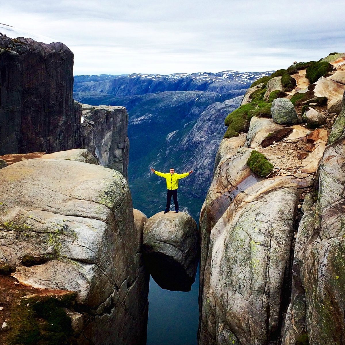
Kjerag is the connoisseur’s choice of the Lysefjord pair. The trail from Øygardstøl tackles three successive granite ridges — the steep slabs have several hundred metres of chains bolted in — before delivering you to a plateau 1,000 m above the fjord, where a glacial boulder sits wedged in a crevasse like a golf ball in a drainpipe. Standing on Kjeragbolten is optional: the staff at Øygardstøl reckon about 45% of hikers look at it and politely decline. No one has ever fallen off, a statistic each visitor gets to keep alive.
The catch is access. The trailhead sits at the top of Lysevegen, a 27-hairpin mountain road from Sirdal that typically opens in late May (occasionally the start of May) and closes by late October — snow decides, not the calendar. Parking is NOK 300. Don’t start late: the staffed season has hard turnaround advice (no later than 4 pm starts in June–July, earlier each month after). Skip the boulder queue and walk five extra minutes to Nesatindane for the better panorama — and, on good days, BASE jumpers stepping off into the void. Car-free, there’s a seasonal Kjerag Express bus from Stavanger or the gorgeous approach by Lysefjord ferry to Lysebotn. Full Kjeragbolten guide coming soon.
Trolltunga sits above the Hardangerfjord, and the approach logistics — three trailheads, three parking tariffs and a shuttle that only runs part of the season — are set out in full in our Hardangerfjord guide.
The ridge walks: Besseggen and Romsdalseggen
Besseggen: Norway’s favourite day in the mountains
14 km point-to-point | ~1,100 m ascent | 6–9 hours | Demanding, some scrambling | Season: July–late September
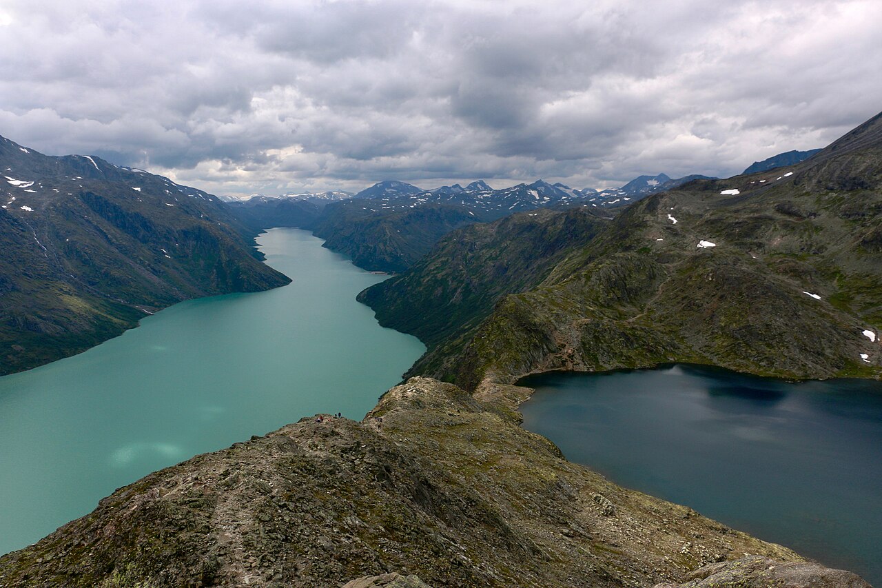
Ask a Norwegian to name one hike and odds are you’ll hear Besseggen. The classic route starts with the morning Gjendebåten boat across Lake Gjende from Gjendesheim to Memurubu (20 minutes, NOK 260 one way in 2026, book ahead at gjende.no — summer sailings genuinely sell out), then climbs back east along the ridge. The famous moment comes mid-route: you’re scrambling a rock spine with emerald-green Gjende 400 metres below on one side and the deep-blue Bessvatnet just 30 metres below on the other. Two lakes, two colours, one ridge. Henrik Ibsen sent Peer Gynt galloping along it on a reindeer; thirty-to-sixty-thousand people a summer now follow at a more sensible pace.
The scrambling section is hands-on but short, and ascending it (the standard direction) is far easier than descending. Snow can linger into early July; the boat runs from June but the ridge is at its best July through late September. Gjendesheim has a staffed DNT lodge at the trailhead — sleeping there the night before makes the morning boat civilised. Full Besseggen guide coming soon in this series.
Romsdalseggen: the most beautiful ridge walk in Norway?
10 km point-to-point | ~970 m ascent | 7–8 hours | Demanding, exposed | Season: July–September
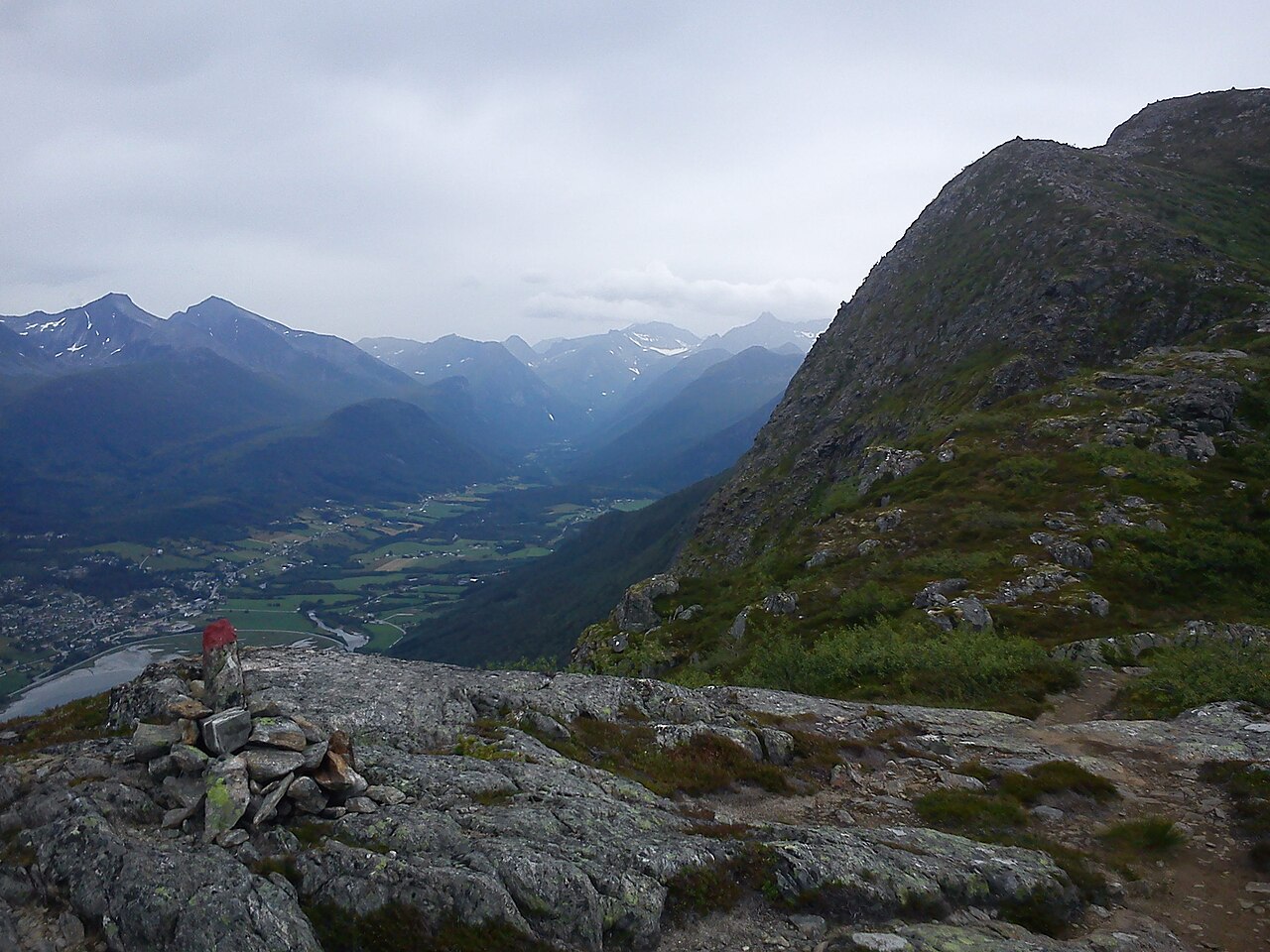
The tourist board calls Romsdalseggen “Norway’s most beautiful hike,” and for once I won’t argue with marketing. A morning shuttle bus from Åndalsnes drops you at Venjedalssetra, and the route traverses an alpine ridgeline staring straight at the Trollveggen — Europe’s tallest vertical rock face — before descending 970 vertical metres back into town via the Rampestreken viewpoint. There’s a section of chains and real exposure on the standard route, plus an “easy” bypass variant and an “extreme” knife-edge variant for people who think chains are cheating.
What makes it logistically lovely: Åndalsnes is the terminus of the Raumabanen, one of Europe’s great scenic railway branches, so this is a hike you can reach by train from Oslo or Trondheim, walk hotel-to-hotel, and celebrate at the town brewery. July to September only — the ridge holds snow late. Full Romsdalseggen guide coming soon.
Reinebringen: Lofoten’s 1,974 steps
The step count is worth a caveat: sources give 1,566, 1,972, 1,974 and 1,978, and none of them is official — call it roughly 1,500 to 2,000. ~2 km round trip (plus a 2 km walk-in from Reine) | ~450 m ascent | 2–3 hours | Short but relentlessly steep | Season: May–September
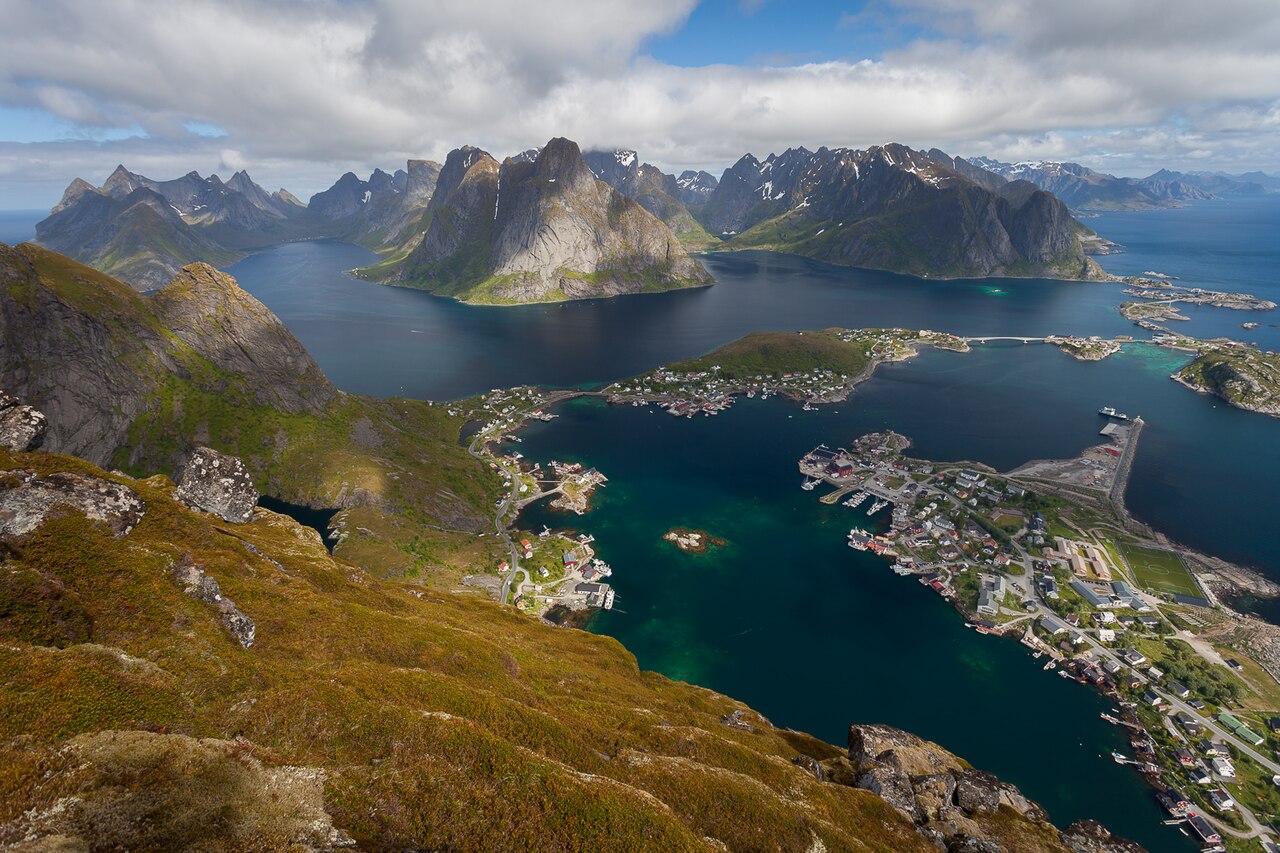
The view from Reinebringen’s summit — the village of Reine scattered across turquoise water, ringed by granite spires — is the single most photographed panorama in northern Norway, and one of the best reasons to visit the Lofoten Islands at all. The hike itself is a stone staircase, 1,974 steps as last counted, built by Nepalese Sherpa stonemasons to save the mountainside from being loved to death. It gains about 450 vertical metres in well under 2 km, which your thighs will register as a very long hour.
Crucial caveats: the stairs are emphatically not a winter route — the official season is May to September, with strong closure advisories when ice arrives — and short summer closures happen while stair work continues, so check locally before walking out. The trailhead sits by the Ramsvik tunnel, a 25–30 minute walk from Reine; there’s no parking at the trail itself. Go at midnight in June if you can: midnight sun turns the whole archipelago gold and you’ll have the steps nearly to yourself. Full Reinebringen guide coming soon in this series.
Brilliant day hikes beyond the icons
The famous six absorb 90% of the foot traffic, which leaves an entire country of equally good walking conveniently empty. A shortlist I’d stake my boots on — and our dedicated guide to the best day hikes in Norway will go deeper:
In fjord country
- Dronningstien (the Queen’s Trail), Hardanger — 16 km point-to-point high above the Sørfjord between Kinsarvik and Lofthus, with the Folgefonna glacier filling the horizon. A seasonal shuttle (NOK 200) links the trailheads. The thinking hiker’s alternative to Trolltunga, one fjord arm over.
- Aurlandsdalen, Sogn — the Østerbø-to-Vassbygdi valley walk, about 20 km mostly downhill through what Norwegians call their Grand Canyon. Ends near Flåm, so it slots perfectly into a fjord-region trip.
- Bondhusvatnet, Folgefonna — a flat 4.5 km return to a glacier lake that out-performs hikes five times harder. Take the kids.
- Skageflå, Geiranger — the abandoned fjord farm perched 250 m above the Geirangerfjord. Combine the boat drop-off with the hike out for the full drama. (Arriving by ship? It’s the best shore excursion on any fjord cruise itinerary.)
In the north
- Ryten & Kvalvika Beach, Lofoten — 7 km round trip to a 543 m clifftop above a wild golden surf beach. Camp on the sand below if the forecast smiles.
- Segla and Hesten, Senja — the sail-shaped peak you’ve seen on every Norway poster. Hike Hesten (5 km round trip, ~520 m) for the postcard angle of Segla’s overhanging prow. Senja is an easy add-on from Tromsø.
- Fløya and Fjellheisen trails, Tromsø — ride the cable car up, walk the high plateau, and in late summer watch for the season’s first northern lights from 421 m.
In the east and the cities
- Gaustatoppen, Telemark — 9 km round trip, ~700 m up, to a 1,883 m summit from which, on a clear day, you can supposedly see a sixth of mainland Norway. There’s a DNT café on top, because Norway.
- Knutshøe, Jotunheimen — the “secret Besseggen”: a 12 km loop along a grassy, occasionally hands-on ridge directly across Lake Gjende, with no boat to book and a tenth of the people.
- Galdhøpiggen — northern Europe’s highest summit at 2,469 m. From Juvasshytta it’s a guided rope-team walk across the Styggebreen glacier (~11 km round trip); from Spiterstulen it’s glacier-free but a 1,360 m grind. Either way, you’ve climbed the roof of Norway.
- Vidden, Bergen — the 13–15 km plateau traverse between Ulriken and Fløyen is the best urban-adjacent mountain walk in Europe. Cable car up, funicular down, fish soup after — Bergen does hiking properly.
- Nordmarka, Oslo — take the T-bane to Sognsvann or Frognerseteren and walk straight into a forest the size of a small country. Oslo is the only capital I know where the metro has trailheads.
Multi-day treks: Norway on foot for a week
Day hikes are Norway’s shop window; the multi-day routes are the actual store. With huts every 4–8 hours of walking and trails marked by those red Ts, this is the easiest country in the world to backpack without carrying a tent or food — though the right to roam means you can do it the hard way for free. Our full guide to multi-day trekking in Norway is coming in this series; the headline routes:
- The Jotunheimen triangle (Gjendesheim–Memurubu–Gjendebu, 2–3 days). Combines Besseggen with the quieter Bukkelægret climb and lakeside walking, sleeping at staffed lodges. The single best introduction to Norwegian hut trekking.
- Hardangervidda crossings (3–5 days). Europe’s largest mountain plateau: huge skies, reindeer herds, and a hut network that lets you cross from Finse (on the Oslo–Bergen railway) southward. One caution: a landowner dispute closed a handful of Hardangervidda cabins and routes in winter 2025/26 — check current cabin status on ut.no when planning.
- Trollheimen’s “Trekanten” triangle (3 days). Three classic lodges, three mountain passes, far fewer tourists. Norwegians’ sentimental favourite.
- Rondane circuits (2–4 days). Norway’s first national park (1962) is gentler, drier and rounder than Jotunheimen — ideal for a first unsupported trip.
- Aurlandsdalen over two days adds the high route above the valley walk, finishing at the fjord in Flåm.
The DNT hut system: Norway’s best-kept open secret

The Norwegian Trekking Association — DNT, founded 1868, 300,000+ members — runs around 550 cabins across the country, and understanding the system unlocks a kind of hiking that simply doesn’t exist elsewhere. There are three flavours:
- Staffed lodges (42 of them): proper mountain hotels with made beds, drying rooms, showers, and a three-course dinner that will ruin you for trail mix. No key needed; book online.
- Self-service cabins: locked with the universal DNT key, equipped with bunks, firewood, gas and — the magic part — a stocked pantry of food you pay for on an honesty system. Crispbread, soup, tinned reindeer meatballs: dinner is provided, trust is assumed.
- No-service cabins: same key, bring your own food.
The numbers, as of the 2026 season: adult membership costs NOK 860 (about $90) a year and pays for itself in two or three nights via member rates. At staffed lodges, full board — bed, breakfast, packed lunch and that dinner — runs roughly NOK 1,095–1,315 for members depending on room type (NOK 1,430–1,710 for non-members). A dorm bed alone is NOK 290 for members. Self-service cabin nights are cheaper still. The universal key costs a refundable NOK 100 deposit at any DNT office or staffed lodge. One rule I love: nobody is turned away — if the bunks are full, you get a mattress on the floor. Plan routes and book beds via ut.no and hyttebestilling.dnt.no.
When to hike in Norway: month by month
The single most common mistake I see is assuming Norway’s mountains work on a Central European calendar. They don’t — snow owns the high country for eight months a year. Pair this table with our month-by-month Norway guide for the full picture:
| Month | High mountains (Jotunheimen, ridges) | Fjord icons (Preikestolen, Trolltunga, Kjerag) | Lofoten & the north |
|---|---|---|---|
| Jan–Mar | Ski territory only | Preikestolen with spikes; Trolltunga guided snowshoe trips | Aurora season; trails icy — Tromsø cable-car walks |
| April | Still ski season | Preikestolen quiet and partly snowy | Stairs icy; not yet |
| May | Snowbound | Preikestolen lovely; Kjerag road opens late month (some years) | Season starts; midnight sun arrives late May |
| June | Snow patches; Besseggen boat starts, ridge still snowy early month | Trolltunga self-guided from 1 June; all three icons go | Prime time begins; 24-hour light |
| July | Everything open; busiest | Peak crowds — start by 7 am | Peak season; book beds early |
| August | Prime; berries everywhere | Still busy; light starts shortening | Superb; first auroras late month |
| September | Golden autumn colours; first frosts; Besseggen until late month | Trolltunga self-guided to 30 Sep; quieter and cooler | Moody, beautiful, emptier |
| October | Season over | Kjerag road closes; Preikestolen continues | Reinebringen season ends; storms arrive |
| Nov–Dec | Ski season returns | Preikestolen with spikes for the determined | Polar night; aurora, not hiking |
My pick for the sweet spot: late August into mid-September. Trails dry, crowds halved, mosquitoes dead, blueberries ripe, mountains turning red and gold — and in the north, the northern lights returning to a sky that still allows hiking by day.
What to pack: gear for Norwegian mountains
Norwegians have a saying you will hear until you flee the country: det finnes ikke dårlig vær, bare dårlige klær — there’s no bad weather, only bad clothing. The DNT-approved summer day-hike kit, which I’ve learned not to argue with:
- Wool base layer (the national religion; cotton kills, as the mountain rescue posters put it)
- Insulating mid-layer — fleece or light down, even in July
- Waterproof shell, jacket and trousers — not “water resistant.” Waterproof.
- Hat and gloves, year-round. I have worn both on Besseggen in August and been grateful
- Proper boots with ankle support — the icon trails are rock staircases and bog
- Map and compass plus the UT.no app with offline maps (phone batteries and fog have a relationship)
- More food and water than seems sensible, a headtorch from mid-August onward, and a small first-aid kit
Good news on water: in the high mountains, running streams are generally drinkable — Norwegians fill bottles straight from them. Use judgement below farms and huts. And if you’ve packed wrong, the trailhead operations at Preikestolen, Kjerag and Trolltunga all rent boots, poles and waterproofs for NOK 90–250 a piece, a quiet admission of how many people arrive in trainers.
Staying safe: the Norwegian mountain code
Norway formalised mountain sense into nine rules — fjellvettreglene — after a series of Easter tragedies in the 1950s, and every Norwegian child absorbs them with their mother’s milk. Abridged: plan your route and tell someone; adapt plans to ability and conditions; heed weather and avalanche warnings; be prepared for bad weather even on short trips; carry what you need to help yourself; choose safe routes; use a map and know where you are; don’t be ashamed to turn around; conserve energy and seek shelter if needed.
Rule eight is the cultural heart of it. Turning back in Norway isn’t failure; pressing on into fog because you’ve “come all this way” is how a sunny 10-hour Trolltunga becomes a 2 am rescue. The weather genuinely does change that fast — I’ve started a ridge in T-shirt sunshine and finished it in horizontal sleet, in July.
Practicalities: medical emergency is 113, police 112, and both apps share your GPS position automatically. Mountain rescue — largely volunteer Red Cross teams plus rescue helicopters — is free in Norway; there is no bill waiting at the bottom. Check yr.no for weather and varsom.no for avalanche and flood warnings. Wildlife is a non-issue by global standards: no dangerous snakes to speak of, bears effectively absent from hiking areas. Your enemies are weather, exposure and your own summit fever, in that order.
Not every great view in Norway needs a walk. Several of the best are roadside, and we have costed them — parking, tolls, road opening dates and the light — in the guide to Norway’s fjord viewpoints.
Hiking Norway without a car
Here’s something the rental-car lobby won’t tell you: every single hike in this guide is reachable by public transport. Norway’s trains, buses and ferries are integrated into one journey planner — Entur — and the icons all have seasonal hiker services. (For the bigger transport picture, our Getting Around Norway guide is coming soon.)
- Preikestolen: direct seasonal buses from Stavanger, ~50 minutes, several departures daily from spring to early October. Book online ahead; off-season, take the Kolumbus 100 bus to Jørpeland plus a short taxi.
- Trolltunga: Skyss bus 930 from Bergen to Odda (~3 hours), or the Haukeliekspressen from Oslo with a timed change; then the Odda shuttle to the trailhead, first departures before 6 am in season.
- Kjerag: the seasonal Kjerag Express coach from Stavanger, or — my preference — the Lysefjord car ferry to Lysebotn and the 27-hairpin climb to Øygardstøl. You arrive having already seen the fjord you’re about to stand above.
- Besseggen: train to Otta, summer bus over Valdresflye to Gjendesheim, then the Gjende boat. The whole approach is part of the day.
- Romsdalseggen: the Raumabanen railway to Åndalsnes and the trailhead shuttle from the station. Possibly Europe’s most elegant train-to-trail connection.
- Lofoten: fly to Leknes via Bodø, or take the Bodø–Moskenes ferry (Moskenes is 5 km from Reine); bus 300 is the archipelago’s spine. Services are sparse — a few per day — so screenshot the timetable.
Where a car genuinely earns its cost: Senja, the quieter Hardanger trailheads, and any plan chaining multiple regions in one week. Otherwise, the bus beats white-knuckling a motorhome down Lysevegen.
What hiking in Norway actually costs
Norway is an expensive country in which hiking is nearly free. The trails themselves cost nothing — no permits, no park fees, nothing to book except boats and beds. What you’ll actually spend, at 2026 rates (figure roughly 9–10 kroner to the US dollar at the time of writing — check current rates):
| Item | NOK | Approx USD |
|---|---|---|
| Trail access, all trails, everywhere | 0 | $0 |
| Preikestolen parking (day) | 275 | ~$29 |
| Kjerag parking (Øygardstøl) | 300 | ~$32 |
| Trolltunga parking P2 / P3 (day) | 550 / 600 + 220 toll | ~$58 / $86 |
| Gjende boat (Besseggen), one way | 260 | ~$27 |
| Stavanger–Preikestolen return bus | ~400 | ~$42 |
| DNT membership (adult, year) | 860 | ~$90 |
| DNT staffed lodge, full board (member) | 1,095–1,315 | ~$115–138 |
| DNT dorm bed only (member) | 290 | ~$30 |
| Guided winter Trolltunga | 1,550–1,950 | ~$163–205 |
| Campsite pitch (2 people + tent) | ~200–300 | ~$21–32 |
| Wild camping under allemannsretten | 0 | $0 |
A budget hiker wild-camping and self-catering can walk Norway for the cost of groceries and the odd parking fee. A hut-to-hut week at staffed lodges runs roughly NOK 8,000–10,000 per person with membership. Both are the best money-to-memory ratios in European travel. One 2026 note: a new visitor’s contribution of up to 3% is being added to overnight stays in some municipalities (Lofoten and Tromsø among the early adopters) — tent campers are exempt, fittingly.
Where to base yourself
Norway’s hiking regions each have a natural base camp. Stavanger serves the whole Lysefjord (Preikestolen and Kjerag from one hotel) — our guide to things to do in Stavanger and the Lysefjord covers the city end of that equation, buses and cruises included. Odda — a working town, refreshingly unpolished — owns Trolltunga and the Hardanger trails. Åndalsnes markets itself as the mountaineering capital and backs it up with Romsdalseggen and Rampestreken from the station. Gjendesheim or Lom for Jotunheimen; Reine or Leknes for Lofoten; Bergen when you want seven mountains and a city’s restaurants in the same day; and Tromsø for Arctic trails with cable-car assistance. Where to stay in each — from fjord-side cabins to mountain lodges — is a guide of its own, coming soon on the site.
If you’d rather hand the logistics to someone else, plenty of operators run guided hiking weeks combining the icons — our guide to Norway tours and excursions covers who’s worth your money and when going guided actually makes sense (short version: boats, glaciers, winter, and the Arctic).
Hiking in Norway: your questions answered
What is the most famous hike in Norway?
Preikestolen (Pulpit Rock) is the most hiked, with 300,000+ walkers a year on its 8 km trail. Trolltunga is the most photographed. Besseggen is the one Norwegians themselves vote for. If you have one day and average fitness, do Preikestolen; one day and strong legs, Trolltunga; a love of ridges, Besseggen.
When is the best time for hiking in Norway?
July and August for the high mountains; June through September for the fjord icons; May to September in Lofoten. My favourite window is late August to mid-September — dry trails, autumn colour, half the crowds, and returning northern lights in the north.
Can beginners hike Trolltunga?
Honestly: it’s a poor first hike. The 27 km round trip (20 km from P3 parking) with ~800–1,200 m of climbing is graded “very demanding,” and the benchmark is being comfortable walking 20 km with 800 m of ascent. Start with Preikestolen; if it felt easy, Trolltunga is a realistic next-year goal.
Do you need a guide to hike in Norway?
Not on marked summer trails — navigation is straightforward and guiding is unnecessary for the icons in season. The exceptions: Trolltunga outside 1 June–30 September (officially guided territory), any glacier crossing (Galdhøpiggen from Juvasshytta requires a rope team), and winter mountains generally.
Is hiking in Norway free?
The trails, yes — every one, with no permits or entry fees. You’ll pay for trailhead parking (NOK 275–600 at the icons), seasonal boats and shuttles, and accommodation. Wild camping is free under the right to roam.
Can you camp anywhere in Norway?
Nearly. Allemannsretten lets you tent on any uncultivated land at least 150 metres from inhabited buildings, for up to two nights in one spot (longer in remote mountains). No open fires 15 April–15 September. The icon car parks are the main exception — no camping there.
What are DNT huts and how much do they cost?
A network of ~550 mountain cabins run by the Norwegian Trekking Association — from staffed lodges with three-course dinners (member full board NOK 1,095–1,315) to self-service cabins with stocked pantries on an honesty system. Annual membership is NOK 860 and pays for itself in two or three nights.
How do you get to Preikestolen without a car?
Seasonal direct buses run from Stavanger city centre to the trailhead in about 50 minutes, several times daily from spring to early October — book online in advance. Off-season, take the Kolumbus 100 bus to Jørpeland and a 10-minute taxi.
Is hiking in Norway dangerous? What about wild animals?
Wildlife is the least of your worries — no dangerous snakes, bears effectively absent from hiking regions. The real risks are weather, exposure and overreach: summit temperatures run ~10°C colder than the fjords, and conditions flip fast. Follow the mountain code, check yr.no, and turn around without shame. Emergency numbers: 113 medical, 112 police.
Which is better: Trolltunga or Preikestolen?
Different questions. Preikestolen delivers 90% of the drama for 40% of the effort — the better choice for most travellers. Trolltunga is the bigger achievement and the wilder day. Fit hikers based near Odda with a full day to spend: Trolltunga. Everyone else: Preikestolen, no regrets.
Make hiking the spine of your Norway trip
You don’t need to be a “hiker” to build a Norway trip around trails — you just need to be someone who’d rather earn a view than queue for it. Put one icon at the centre of your week, pad it with the short walks nearby, and let the rest of the country fill in around it. For the full picture of what else belongs on the list, start with our complete guide to things to do in Norway, match your dates against the best time to visit, and steal a route from our itineraries. The mountains have been there ten thousand years. They’ll wait while you book the boots.
About this guide
The NorwayTourism.org team has hiked Norway’s trails across every season — from sunrise queues at Trolltunga to empty September ridges in Jotunheimen. We keep this guide updated with current season dates, parking fees and transport schedules, and we don’t accept payment for recommendations. Found something out of date? Tell us and we’ll fix it.
Sources & further reading
- Trolltunga official site — parking, shuttles, seasons
- Preikestolen 365 — official trailhead and parking information
- Kjerag 365 — trail, road and parking status
- Gjendebåten — Besseggen boat timetables and booking
- DNT — Norwegian Trekking Association — huts, membership, the mountain code
- UT.no — Norway’s national trail planner
- Visit Norway: Hiking — official tourism board resources
- Visit Lofoten: Reinebringen — stairs, seasons and closures
- yr.no and varsom.no — weather and mountain warnings
Beyond the trails, our Norway travel tips guide covers the rest of the planning — right-to-roam rules, driving, money and more.
Photo credits
- Trolltunga’s rock tongue above Ringedalsvatnet — Photo: Frankemann / CC BY-SA 4.0 via Wikimedia Commons (Source)
- The Preikestolen plateau above the Lysefjord — Photo: Sergey Ashmarin / CC BY-SA 3.0 via Wikimedia Commons (Source)
- Kjeragbolten, the boulder in the sky — Photo: Scoundrelgeo / CC BY-SA 4.0 via Wikimedia Commons (Source)
- Besseggen’s two-coloured lakes, Gjende and Bessvatnet — Photo: Silverkey (Mickaël Delcey) / CC BY-SA 4.0 via Wikimedia Commons (Source)
- A red-T cairn on the Romsdalseggen ridge above Åndalsnes — Photo: -Any- / CC BY 3.0 via Wikimedia Commons (Source)
- Reine and the Lofoten peaks from Reinebringen — Photo: Svein-Magne Tunli – tunliweb.no / CC BY-SA 4.0 via Wikimedia Commons (Source)
- Rondvassbu, a staffed DNT lodge in Rondane — Photo: Glivi (Public domain) via Wikimedia Commons (Source)