I checked the five pages ranking for best fjord viewpoints in Norway for three things: a price, an opening date, and any mention of which direction the light comes from.
Between them, across roughly 9,000 words, there was not one 2026 price. Not one toll, parking fee, funicular fare or gondola ticket. No opening dates, so no mention that Trollstigen reopened on 27 April this year after two closed seasons — arguably the biggest piece of viewpoint news in Norway. Two of them still describe Stegastein’s parking as free, which stopped being true this summer. And nothing at all about light, which is the only variable that decides whether the photograph you drove three hours for works.
So here is the version with the numbers. Every viewpoint below has what it costs, whether you drive or walk, how long it takes, when it is open, and when the sun is where you want it. Our main guide covers everything else about planning the fjords, from boats to beds.
The master table
Prices are 2026, adult, converted at 9.35 NOK to the dollar.
| Viewpoint | Access | Time | Cost | Season | Best light |
|---|---|---|---|---|---|
| Stegastein | Drive or bus | 15 min from Aurland | Free entry, paid parking (new for 2026) | Road open all year | Late afternoon; the fjord runs north–south |
| Dalsnibba / Geiranger Skywalk | Drive, toll road | 20 min from Djupvasshytta | NOK 330 ($35) per car | Roughly late May–late Sept | Midday. It is 1,500 m up and shadow is not the issue — cloud is |
| Ørnesvingen (Eagle’s Bend) | Drive | 10 min from Geiranger | Free | All year | Morning, looking down the fjord |
| Flydalsjuvet | Drive | 5 min from Geiranger | Free | All year | Afternoon and evening |
| Vøringsfossen step bridge | Drive | Roadside | Free | All year, bridge weather-dependent | Late morning, when sun reaches the gorge |
| Utsikten, Gaularfjellet | Drive | Roadside at 700 m | Free | Seasonal road | Evening |
| Fløyen, Bergen | Funicular | 8 min ride | NOK 200 ($21) return online, summer | All year | Sunset over the islands |
| Ulriken, Bergen | Cable car | 7 min | NOK 150 ($16) return | All year | Any. It is 643 m and faces west |
| Romsdalsgondolen, Åndalsnes | Gondola | 5 min | NOK 625 ($67) return | All year | Evening light on Romsdalshorn |
| Aksla, Ålesund | 418 steps | ~45 min return | Free | All year | Sunset. This is the one |
| Preikestolen | Hike | ~4 h return | NOK 275 ($29) parking over 2 h | Mainly Apr–Oct | Early morning, before the crowds and the haze |
| Kjeragbolten | Hike | 6–10 h | NOK 300 ($32) parking | Mid-May–end Oct | Midday. You need the light in the chasm |
| Trolltunga | Hike | 7–12 h | NOK 550–800 ($59–86) parking | Guide-free 1 Jun–30 Sept | Morning |
| Reinebringen, Lofoten | Stone stairway | 2.5–3.5 h return | Free | Summer; icy and dangerous off-season | Midnight sun, or golden hour in September |
| Segla, Senja | Hike | ~3.5 h return | Free | Summer | Late evening |
The drive-to viewpoints
Stegastein — and the 2026 change
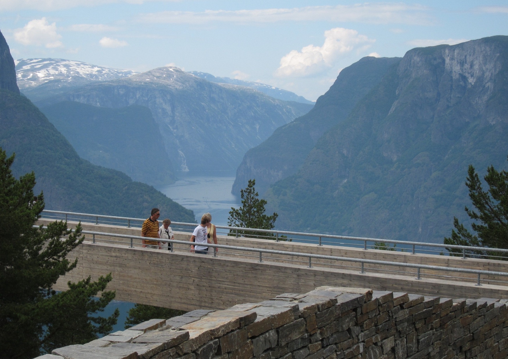
A wooden platform 650 metres above the Aurlandsfjord, running 30 metres out from the hillside and ending at a frameless glass wall that tips the floor towards the water. Opened in 2006, and still the best piece of viewpoint architecture in the country.
Two things you need to know for 2026. First, the road up from Aurland — six kilometres of hairpins on Rv243 — is open all year, though the continuation over Aurlandsfjellet only opened on 1 June this year. Second, Aurland municipality has introduced paid parking with a 30-minute maximum stay, in response to coaches blocking the turning circle. I could confirm the policy but not the fee, and I would rather leave a gap than invent a number — check locally before you go, and do not plan to linger.
Without a car, a shuttle runs from stop C at Flåm station and the round trip takes about 90 minutes. Every fare figure I found for it was at least two years old, so ask at the station rather than trusting a blog. The Flåm guide covers the rest of the valley.
Dalsnibba and the Geiranger Skywalk
The highest fjord view in Europe reachable by road: 1,500 metres, with the Geirangerfjord a vertical mile below you. The Nibbevegen toll road climbs from Djupvasshytta at 1,038 metres and costs NOK 330 ($35) per car. The road is open 24 hours once the season starts, which typically means the second half of May through late September, entirely snow-dependent.
Verdict: worth the toll on a clear day and completely worthless on a cloudy one, because at 1,500 metres you are frequently inside the cloud rather than above the fjord. Check the webcam before you drive up. If it is grey, Ørnesvingen is free and 900 metres lower.
Ørnesvingen and Flydalsjuvet
Geiranger’s two free viewpoints, and between them they cover the fjord better than the paid one.
Ørnesvingen sits at 620 metres on the last hairpin of the Eagle Road, looking straight down the length of the fjord with the Seven Sisters opposite. It is open all year. Parking is very limited and coaches use it, so go early or late.
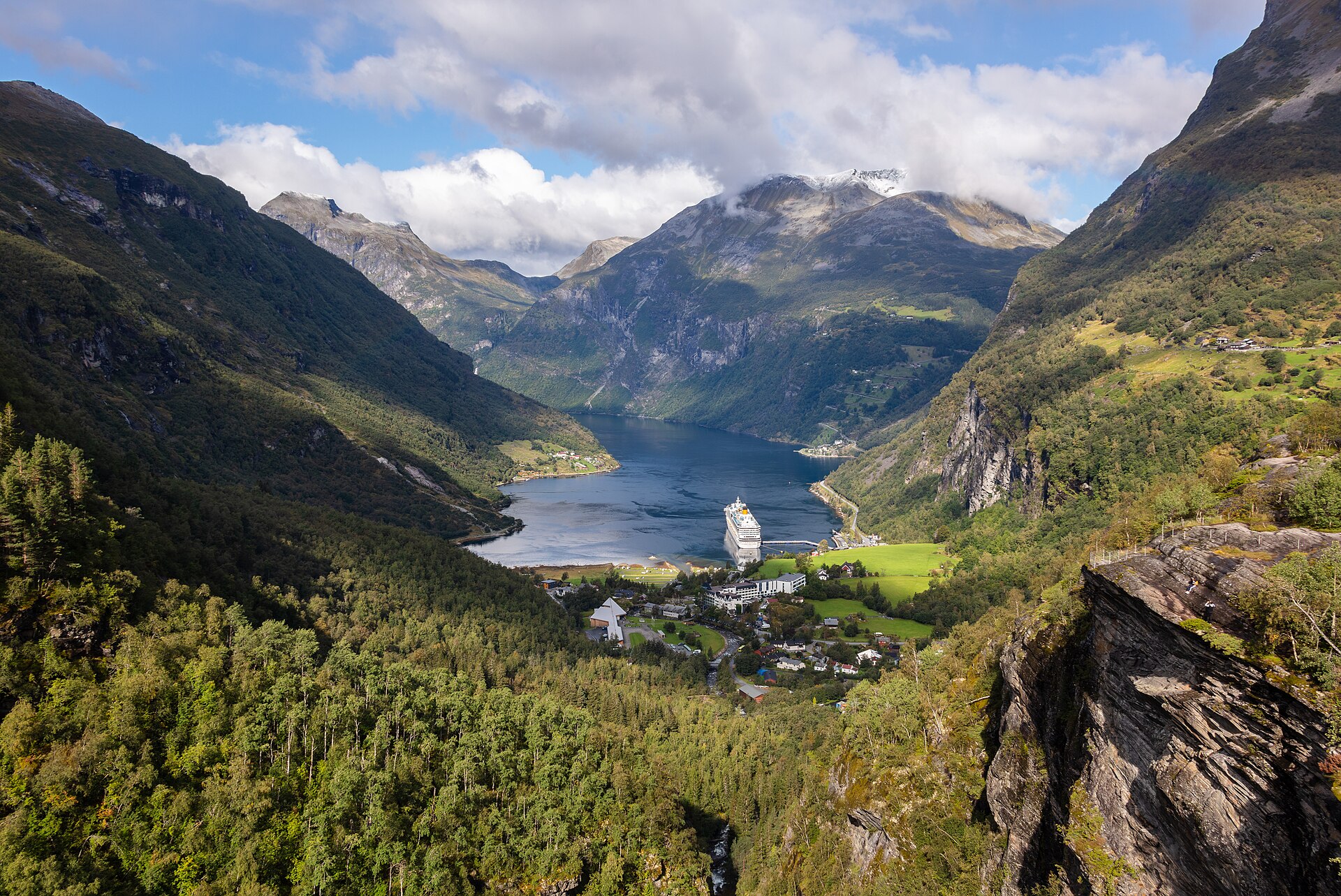
Flydalsjuvet is five minutes above the village, roadside, and gives you the classic view with a cruise ship in it if there is one. The Queen’s Chair — Dronningstolen — is named for Queen Sonja.
Between the two, Ørnesvingen in the morning and Flydalsjuvet in the evening covers the Geirangerfjord in both lights for nothing.
Vøringsfossen
Not a fjord view, but the best-engineered viewpoint in Norway and it is on the Hardanger route. The waterfall drops 182 metres in total with a 145-metre free fall into Måbødalen. The step bridge that opened in 2020 spans 47 metres with 99 steps and a 16-metre height difference end to end, so you cross the gorge above the falls and climb as you go.
Free, roadside, and it turns a photo stop into twenty minutes. More on the waterfall itself and when it runs hardest in our waterfall guide.
Utsikten and Vedahaugane
Two architectural viewpoints on high roads that most visitors never reach. Utsikten on Gaularfjellet was completed in 2016 and sits at 700 metres, looking back down a valley of lakes. Vedahaugane, high on Aurlandsfjellet at around 1,160 metres, has a curved concrete walkway and an art installation — though I could only find this described on one non-official source, so treat the detail loosely.
Both are on seasonal roads. Both are empty.
Viewpoints you ride to
Four mechanical options, and the price spread between them is enormous.
| Fløibanen, Bergen | Ulriken643, Bergen | Romsdalsgondolen | |
|---|---|---|---|
| Height | 320 m | 643 m | 708 m (Nesaksla) |
| Adult return | NOK 200 ($21) online, 1 Apr–30 Sep; NOK 145 in winter | NOK 150 ($16) | NOK 625 ($67) |
| Child | Reduced | NOK 80 | NOK 335 |
| Frequency | Every 10 min | Continuous | Continuous |
| Worth it? | Yes, but walk down | Best value view in Norway | Only if you are not walking up |
A correction worth making. Several sites quote Fløibanen at NOK 350 for a summer adult return. That figure is the day ticket, which gives unlimited rides. The return fare is NOK 200 bought online or from a machine, NOK 220 at the counter, and NOK 145 in the low season. Bergen Card holders get half off. If you have been budgeting 350, you have overpaid by 43%. The funicular is also closed for maintenance for a few days in early November.
Ulriken is the better mountain and the cheaper ticket — 643 metres against Fløyen’s 320, for NOK 150 return. Everyone takes the funicular because it starts in the middle of town. If you have an afternoon in Bergen and a choice, take the cable car.
Romsdalsgondolen at Åndalsnes is the expensive one at NOK 625 return, rising 1,679 metres of cable to Nesaksla at 708 metres, with the Rampestreken platform jutting out below the top station. It is a spectacular position over Romsdalen and the price reflects that it is the only way up without a two-hour climb.
The hikes
Preikestolen
Eight kilometres round trip, about four hours, up to a plateau roughly 25 metres square sitting 604 metres above the Lysefjord. The ascent is usually given as around 500 metres, though some sources say closer to 350 — the trail has been rebuilt in sections and the figures have not all been updated.
Parking, 2026: NOK 275 ($29) for over two hours, NOK 40 for under two, free under fifteen minutes, NOK 100 for a motorcycle, NOK 1,200 for a bus. You pay after the hike. The car parks hold 400 and 600 cars and are open around the clock, but sleeping overnight is not permitted.
Go at dawn. This is the most-walked trail in Norway and by 11:00 in July the queue for the photograph on the edge is real. Start at 06:00 and you will have it. See the Lysefjord guide for the boat that shows you the same rock from below — which is the only way to grasp how high it is.
Kjerag
Six to ten hours, three steep ascents and descents, to a boulder wedged in a chasm about a thousand metres above the fjord. Parking is NOK 300 ($32) for over two hours, NOK 30 under two, and the road is open from mid-May to the end of October before it closes for winter. Four hundred spaces.
Harder than Preikestolen by a wide margin and far less busy for exactly that reason.
Trolltunga
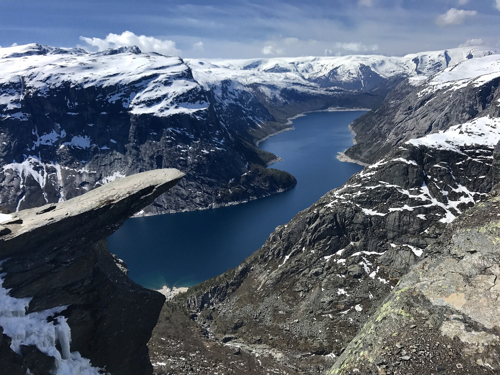
The one people underestimate. From the lower car park, P2 Skjeggedal, it is 28 kilometres return with 800 metres of ascent and takes 10 to 12 hours. From P3 Mågelitopp, higher up, it is 20 kilometres and 300 metres, taking 7 to 10 hours.
Parking, 2026: P2 is NOK 550 for one day, NOK 770 for two, NOK 990 for three, toll included. P3 is around NOK 600–800 depending on source, plus a toll quoted variously at NOK 200 and NOK 220 — I could not resolve that discrepancy. P3 has only about 30 spaces and must be pre-booked in high season.
The guide-free season runs 1 June to 30 September; P3 opens 8 June. Outside that window you are legally required to go with a guide, and people still ignore it and get into trouble. Our hiking guide covers the grading system and the mountain code.
Reinebringen, Lofoten
A 448-metre summit above Reine, reached by a Sherpa-built stone stairway that replaced an eroded mud scramble. About an hour up, two and a half to three and a half hours in total.
The step count is genuinely disputed — I found 1,566, 1,972, 1,974 and 1,978 across four sources, none of them official. “Roughly 1,500 to 2,000, and nobody agrees” is the honest answer, and you will not be counting after the first three hundred anyway.
The view is the most photographed in northern Norway. In June you can climb it at midnight in full daylight, which is the version worth planning for. In winter the steps ice over and it becomes genuinely dangerous. More on the region in the Lofoten guide.
Segla, Ryten and Aksla
Segla on Senja: 639 metres, about 600 metres of ascent, roughly three and a half hours return, for a blade of rock rising straight out of the sea. Arctic Norway’s best single viewpoint and a fraction of the traffic Lofoten gets.
Ryten and Kvalvika in Lofoten: 7.8 kilometres return, four to six hours, over a ridge to a beach with no road to it.
Aksla in Ålesund: 418 steps from Byparken to the Fjellstua at 165 metres, about 45 minutes return, free. The cheapest genuinely great view in Norway — the whole art nouveau town spread below with the Sunnmøre Alps behind. Do it at sunset.
Light: the section nobody writes
A fjord is a north–south or east–west trench a kilometre deep. That geometry decides everything about when a viewpoint works, and it is why people drive for hours and photograph a shadow.
The fjord floor gets sun late and loses it early. In a steep fjord in spring and autumn, direct sunlight may only reach the water for a few hours around midday. Villages like Geiranger and Flåm sit in shade for months in winter. If you want the water lit rather than the walls, go at midday and go in summer.
Morning for east-facing, evening for west-facing. Ørnesvingen looks west down the Geirangerfjord, so morning puts the sun behind you. Flydalsjuvet works the other way. Aksla in Ålesund faces west over the sea — sunset, always.
The midnight sun changes the rules entirely. North of the Arctic Circle, from roughly late May to mid-July, the sun does not set. Reinebringen and Segla at 23:00 give you low golden light with nobody else on the summit. This is the single biggest advantage of travelling north in June.
Late August and September give the best light in the south. Lower sun angle, longer golden hours, autumn colour on the fjord walls, and the summer haze gone. If photography is the reason you are coming, this is the window.
For aurora photography, which is a different craft entirely, see our guide to photographing the northern lights.
Which ones are open in winter
Most viewpoint articles are written for July and quietly assume you are too. Between November and April the map looks entirely different.
| Viewpoint | Winter status |
|---|---|
| Stegastein | Open. The Aurland road is cleared all year. Snow on the platform, fjord below, nobody there |
| Ørnesvingen | Open. The Eagle Road stays open year-round |
| Fløyen and Ulriken | Open. Both run all year; Fløibanen is cheaper in winter at NOK 145 |
| Romsdalsgondolen | Open all year |
| Aksla, Ålesund | Open, though the steps ice up |
| Vøringsfossen | Road open; the bridge and paths depend on conditions |
| Dalsnibba | Closed. Under snow |
| Trollstigen | Closed, typically November to late April |
| Aurlandsfjellet, Gaularfjellet, Sognefjellet | Closed or heavily restricted |
| Trolltunga, Kjerag | Closed to unguided walkers |
| Preikestolen | Trail technically open; requires winter equipment and experience |
| Reinebringen | Steps ice over. Genuinely dangerous — people are injured on it every winter |
The winter list is shorter but the experience is not worse. Stegastein in February, with the fjord black and the walls white and one other car in the car park, is better than Stegastein in July with three coaches. What you lose is the high roads and the hikes; what you gain is having the accessible ones to yourself.
Overrated and underrated
Having been to most of these, here is where my opinion diverges from the internet’s.
Overrated: Trolltunga. Not the place — the ledge is extraordinary — but its position in people’s plans. It has become a photograph people organise a trip around, and the reality is a ten-hour mountain day, a NOK 550 car park, a queue at the top, and a three-month window when you can legally do it unguided. Plenty of people would enjoy Preikestolen more and admit it afterwards.
Overrated: Fløyen. Pleasant, and the funicular is a nice ride. But it is 320 metres, it is busy, and Ulriken is twice the height for less money. Fløyen is where everyone goes because it starts downtown.
Underrated: Aksla in Ålesund. Four hundred and eighteen steps, free, forty-five minutes, and the view is a complete art nouveau town on an island with alps behind it. Nothing else in Norway gives you that much for that little.
Underrated: Ulriken. NOK 150 return for 643 metres. If you are in Bergen for one afternoon, this is the best value view in the country.
Underrated: Segla on Senja. Comparable to anything in Lofoten, three and a half hours of walking, and you may well have the summit to yourself. Senja gets a fraction of Lofoten’s traffic for reasons that are entirely about marketing.
Underrated: the Rimstigen trail above the Nærøyfjord. Steep and unglamorous, and it delivers the view every professional photograph of the Nærøyfjord is taken from. Almost nobody walks it because the boat is right there.
If you are still deciding which fjord to build the trip around, the head-to-head is in which fjord to visit in Norway, and the scenery-first ranking is in the most beautiful places in Norway.
Drones: what the rules actually are
Norway follows the EASA framework. In the open category that means a maximum height of 120 metres above ground, the drone kept within visual line of sight, and a weight limit of 25 kilograms.
Anything from 250 grams up, or any drone with a camera, requires operator registration at flydrone.no. Registration lasts a year, and there is an online A1/A3 theory exam. There is a five-kilometre no-fly radius around airports, and restrictions inside national parks — in Svalbard, national parks and nature reserves are closed to drones outright.
There is one Norway-specific rule that catches visitors: foreign citizens are required to register camera and sensor use with the national security authority before flying. Check the current requirement before you travel rather than at the trailhead.
Practically: the popular viewpoints are busy, and flying a drone over a queue of people at Preikestolen will make you unpopular before it makes you illegal. The empty ones — Segla, Gaularfjellet, the Hjørundfjord — are where a drone earns its weight.
What to skip
Skip Dalsnibba if the cloud base is below 1,200 metres. NOK 330 to drive into fog. The webcam is free and it is the single best thirty seconds you can spend before setting off.
Skip Fløibanen’s day ticket unless you are going up twice. The return fare is NOK 200; the day ticket is NOK 350. Almost nobody rides it twice.
Skip Trolltunga unless you actually want a ten-hour mountain day. It is a photograph that has convinced thousands of people to attempt a serious hike in trainers. Mountain rescue in Norway gets called out to this trail more than any other. If you want a dramatic rock ledge with a fraction of the effort, Preikestolen is four hours and Ørnesvingen is a car park.
Skip Preikestolen between 10:00 and 15:00 in July. Not the hike — the timing. Same trail, same view, an entirely different experience at 06:00.
Skip the Geiranger viewpoints on a two-ship day. Eighty-plus cruise calls are scheduled for 2026 with ships up to 6,600 passengers, and they all buy the same coach tour to the same three car parks. Our advice on timing a Geiranger visit around the ships applies to the viewpoints too.
Skip stacking three viewpoints into one day. The temptation is to treat them as a checklist. But Stegastein at the wrong hour is a grey view, and the difference between a good viewpoint day and a bad one is waiting for the light rather than driving to the next one.
Building a viewpoint route
| Days | Route | Viewpoints | Car? |
|---|---|---|---|
| 1 | Bergen | Ulriken, Fløyen | No |
| 1 | Stavanger | Preikestolen at dawn, Lysefjord by boat | No |
| 2 | Flåm and Aurland | Stegastein, Rimstigen, Aurlandsfjellet if open | Helpful |
| 3 | Geiranger and Åndalsnes | Ørnesvingen, Flydalsjuvet, Dalsnibba, Trollstigen, Rampestreken | Yes |
| 4 | Hardanger | Vøringsfossen, Trolltunga, Skjervsfossen | Yes |
| 4 | Lofoten and Senja | Reinebringen, Ryten, Segla | Yes |
The three-day Geiranger–Åndalsnes loop is the best viewpoint driving in Norway, and Trollstigen reopening on 27 April 2026 — its earliest ever opening, after being closed for rockfall stabilisation — makes it viable for a much longer season than in recent years. If you are planning a wider route, our fjord geography guide explains which of these regions actually connect. For the day-by-day version, see our driving itinerary with the ferry times.
Frequently asked questions
What is the best fjord viewpoint in Norway?
Stegastein, for the combination of drama and accessibility — 650 metres above the Aurlandsfjord, reachable by car all year and by bus in summer, free to walk onto. Ørnesvingen over the Geirangerfjord is the better view; Stegastein is the better viewpoint.
Is Stegastein free to visit?
The platform itself is free. Parking is not, as of the 2026 season, and there is now a 30-minute maximum stay. The fee had not been published anywhere I could verify at the time of writing.
How do you get to Stegastein without a car?
A shuttle bus from stop C at Flåm station, roughly 90 minutes for the round trip including time on the platform. Fares have changed recently enough that I would not trust a figure from any article, including older ones on this site — ask at the station.
How much does it cost to drive up to Dalsnibba?
NOK 330 ($35) per car for the Nibbevegen toll road, which climbs from Djupvasshytta to the Geiranger Skywalk at 1,500 metres. The road opens when the snow clears, usually in the second half of May, and closes around late September.
Is Trollstigen open in 2026?
Yes. It opened on 27 April 2026, the earliest opening on record, following stabilisation work after the rockfall that closed it. It normally runs until October or November, with short weather closures possible.
Do you have to hike to see the Geirangerfjord?
No. Ørnesvingen and Flydalsjuvet are both roadside and free, and Dalsnibba is a toll road. Geiranger is unusual among Norway’s great fjords in that the best views require no walking at all.
How long does the Preikestolen hike take?
About four hours return for eight kilometres, with roughly 500 metres of climbing — though the ascent figure varies between sources. Add an hour if you want time at the top without a queue, and start early.
Can you fly a drone over the Norwegian fjords?
Within the EASA open-category rules: under 120 metres, within sight, registered as an operator if the drone is 250 grams or over or carries a camera. Airports have a five-kilometre exclusion zone and national parks have restrictions. Foreign citizens have an additional registration requirement for camera and sensor use.
Which viewpoint is best for photographs?
Ørnesvingen in the morning for the classic Geirangerfjord shot, Aksla at sunset for Ålesund, Reinebringen under the midnight sun for Lofoten. Several of Norway’s most photographed landmarks are best seen from a viewpoint rather than up close.
Photo credits
- Stegastein, 650 metres up. The road from Aurland is cleared all year, unlike almost everything else at this height. — Photo: Erik den yngre / CC BY-SA 3.0 via Wikimedia Commons.
- Trolltunga: 20 to 28 kilometres of walking depending on the car park, and NOK 550–800 to leave the car. — Photo: kallerna / CC BY-SA 3.0 via Wikimedia Commons.
- Flydalsjuvet is five minutes above Geiranger, free, and best in the evening. — Photo: Diego Delso / CC BY-SA 4.0 via Wikimedia Commons.
Prices, tolls and season dates checked 1 September 2026 and converted at 9.35 NOK to the US dollar. Parking fees at the major trailheads rose this year and may rise again. The Stegastein parking charge and the Flåm–Stegastein bus fare were both unpublished at the time of writing and I have deliberately left them blank rather than guess. Mountain road openings vary by up to four weeks between seasons.